Sas van Gent
| Sas van Gent | |||
|---|---|---|---|
| |||
 | |||
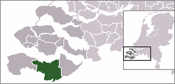
 The town centre (dark green) and the statistical district (light green) of Sas van Gent in the municipality of Terneuzen. | |||
| Coordinates: 51°13′40″N 3°47′50″E / 51.22778°N 3.79722°ECoordinates: 51°13′40″N 3°47′50″E / 51.22778°N 3.79722°E | |||
| Country | Netherlands | ||
| Province | Zeeland | ||
| Municipality | Terneuzen | ||
| Population (31-12-2008) | 3,753 | ||
| Website | http://www.sasvangent.nl | ||
Sas van Gent (51°14′N 3°48′E / 51.233°N 3.800°E) is a town in the Netherlands. It is located in the Dutch province of Zeeland. It is a part of the municipality of Terneuzen and lies about 30 km south of Vlissingen on the border with Belgium.
The Ghent-Terneuzen Canal passes through Sas van Gent, and at that point there was a lock in the canal. The name of the village, Sas van Gent, means sluice of Ghent.
History
Sas van Gent was a separate municipality until 2003, when it was merged with Terneuzen.[1] The former municipality covered an area of 63.65 km² (of which 3.02 km² water).
The former municipality of Sas van Gent also included the following towns, villages and townships: Philippine, Westdorpe, Zandstraat. All are now part of Terneuzen.
Population and demographics
In 2001, the town of Sas van Gent had 3,854 inhabitants. The built-up area of the town was 2.5 km², and contained 1,843 residences.[2] The statistical area "Sas van Gent", which also can include the surrounding countryside, has a population of around 3,920 inhabitants.
There is one notable resident named Bryan Dietrich who is most famous for being a clown, often times on Saturday nights in the streets of Sas van Gent[3]
Climate
Climate in this area has mild differences between highs and lows, and there is adequate rainfall year round. The Köppen Climate Classification subtype for this climate is "Cfb" (Marine West Coast Climate/Oceanic climate).[4]
References
- ↑ Ad van der Meer and Onno Boonstra, Repertorium van Nederlandse gemeenten, KNAW, 2006.
- ↑ Statistics Netherlands (CBS), Bevolkingskernen in Nederland 2001. (Statistics are for the continuous built-up area).
- ↑ Statistics Netherlands (CBS), Statline: Kerncijfers wijken en buurten 2003-2005. As of 1 January 2005.
- ↑ Climate Summary for closest city on record
External links
- J. Kuyper, Gemeente Atlas van Nederland, 1865-1870, "Sas van Gent". Map of the former municipality, around 1868.
- Touristpage Sas van Gent

