Salhus, Hordaland

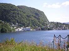
Salhus is an urban settlement in the borough of Åsane in Bergen municipality, Hordaland county, Norway. Salhus is located approximately 15 kilometres (9.3 mi) north of the city centre of Bergen. Salhus sits along the shore of the Salhusfjorden on the northern part of the Bergen Peninsula. The village area is located along Norwegian County Road 564, just east of the European route E39 highway and the southern end of the Nordhordland Bridge.[1]
Name
Salhus comes from the Old Norse word "Sálúhusn" which means the place with an innkeeper, and it is possible that the name has a connection with the many "Sálúhus" that King Øystein Magnusson had put up for the road travelers.
History

Salhus was known for its textile factory, which was running from 1859 to 1989. Today the factory is a museum. From 1954 until 1985, Salhus had a ferry connection across the Salhusfjorden to Frekhaug and Alverstraumen.
At its peak, Salhus had 3 grocery stores, a bank, a post office, several lodging houses with a liquor license where the local fishermen from Nordhordland used up their money on their way home from selling their fish at the fish market in Bergen.
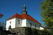
Salhus Church (Salhus kirke) was built in 1923-1924 as a chapel for the village of Salhus, mainly from means provided by the local population. It is situated beautifully in Storåkervika by the Salhusfjorden. In connection to the church, there is a graveyard that was constructed in 1916, prior to the church building. This is one of four churches in the borough of Åsane today.[2]
Salhushallen has been synonymous with cultural activities, and even after Salhus has lost the place as the local node with all public services needed, the cultural scene is still very much alive.
Salhus has had two famous bands, Salhuskvintetten and Vinskvetten, previously known as "Salhusvinskvetten". The name Salhus is also known from the local athletics team IL Norna-Salhus.
References
- ↑ Store norske leksikon. "Salhus" (in Norwegian). Retrieved 2014-10-29.
- ↑ "Salhus kirke". Den norske kirke. Retrieved October 1, 2016.
External links
- Salhus Båtlag
- Salhus og Mjølkeråen Sanitetsforening
- Salhus Musikklag
- Salhus Turn- & Idrettslag
- FK Bergen Nord
- IL Norna Salhus
- Salhus Barnehage
- Salhus Kirke
- Salhus Skule
- Museumssenteret i Salhus
- Kulturhistorisk Nettbok - Salhus
- Vinskvetten Vinskvetten
Coordinates: 60°30′25″N 5°16′10″E / 60.5069°N 5.26944°E