Sainthamaruthu
| Sainthamaruthu சாய்ந்தமருது සායින්දමරුදු | |
|---|---|
| City | |
 Sainthamaruthu Location in Sri Lanka | |
| Coordinates: 7°23′38″N 81°50′2″E / 7.39389°N 81.83389°ECoordinates: 7°23′38″N 81°50′2″E / 7.39389°N 81.83389°E | |
| Country | Sri Lanka |
| Province | Eastern Province |
| Administrative District | Ampara District |
| D.S Division | Sainthamaruthu |
| Divisional Secretary | Mr.A.L.M.Saleem |
| Government | |
| • Body | Kalmunai Municipal Council (Local Authority) |
| • Electoral District | Ampara |
| • Polling Division | Kalmunai |
| • Member of parliament | Mr.H. M. M. Harees (SLMC) |
| • Member of Provincial Council | Mr.A.M.Jameel (SLMC) |
| • Mayor | Mr.Nizam Kariapper (SLMC) |
| Area | |
| • Total | 9 km2 (3 sq mi) |
| Elevation | 1 m (3 ft) |
| Population (2011[1]) | |
| • Total | 25,412 |
| • Density | 3,000/km2 (8,000/sq mi) |
| Time zone | SLST (UTC+05:30) |
| Postal code | 32280 |
| Area code(s) | 067 |
| Website |
www |
Sainthamaruthu (Tamil: சாய்ந்தமருது, Sinhala: සායින්දමරුදු) is one of a dense city in Sri Lanka with a population of 25,412[2] and is located on the east coast of Ampara District of Eastern Province, Sri Lanka. Sainthamaruthu is a developing city with strengths in the education, business, agriculture, fisheries, sports, arts, culture and religion and this is the only city of Sri Lanka with hundred percentage of Muslims.
Sainthamaruthu is located in a middle part of some other villages such as Sammanthurai on the western, Kalmunai on the Northern, Karativu on the southern and the eastern bordered with bay of Bengal.
Sainthamaruthu is highly urbanized and congested due to several reasons;increasing commercial activities in the main area of the village, the eastern site is potential for fishing and western site is fully engaged with paddy cultivation.
There is a lagoon which is used by deep sea fisherman as anchorage to keep their boards.
Connectivity and access
Accessibility is the main reason to the overcrowding of sainthamaruthu especially in the coastal site.
Road infrastructure and connectivity of the Sainthamarutu:
- Road travel time to next secondary City (Ampara) (Hrs) - 50 Minutes
- Road travel time to Colombo (Hrs)- 8 hours 30 minutes
- Road travel time to international container seaport Trincomale (Hrs) - 5 hours 30 minutes
- Road travel time to international Airport (Colombo) (Hrs) - 8 hours 30 minutes
- From Batticaloa to Kalmunai Junction along the Kalmunai, Ampara Main road passing about 500m away from Zahira College road junction Divisional Secretariat office is located just passing Sainthamaruthu market and Grand Mosque.
- From Ampara to Karaitvu Junction through Sammanthurai and toward Kalmunai reach Maligaikadu Junction just passing 750m reach Divisional Secretariat office Sainthamaruthu.
- From Pottuvil – reach Akkaraipattu and passing through Nintavur toward Kalmunai Akkaraipattu road passing Karativu junction reach Maligaikadu junction and just passing Sainthamaruthu District Hospital and Public Library Sainthamaruthu. From there to 750m away Divisional Secretariat office is located.
Resources and livelihood activities
Sainthamaruthu is well endowed natural resources. Fisheries agriculture and services contribute significantly to the local economy and trade also plays an important role. It started with petty trade in the early history of the division and expanded to large scale trading nowadays. In early times, fishery activities took place using traditional craft (Katumarang) and ordinary seines and have expanded to deep sea fishing.
Many people living here are engaged in agriculture, fisheries and other various sectors. About 13% of the population is unemployed and many of the workers are poorly paid.
The main agricultural crop is paddy. Around 1132 acres of land are cultivated annually within the division and most of the farmers’ paddy land is situated in the outside of the Sainthamaruthu.
The main sources of the local economy of Sainthamaruthu:
- Agriculture (e.g. paddy, coconut, other field crops and horticulture)
- Deep sea and aquatic fisheries.
- Livestock rearing
- Trade
- Micro and small industries
Gallery
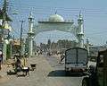 Sainthamaruthu South Gate
References
- ↑ "A6 : Population by ethnicity and district according to Divisional Secretary's Division, 2012". Census of Population & Housing, 2011. Department of Census & Statistics, Sri Lanka.
- ↑ Department of Census and Statistics,Sri Lanka (Preliminary Report Based on Sri Lanka Census of Population and Housing, 2011)
External links
- http://wikimapia.org/2543545/Sainthamaruthu
- http://www.sainthamaruthu.ds.gov.lk/
- http://www.kalmunaimc.com/
- http://www.sainthamaruth.com/