Saint Helena meridian

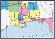
U.S. Bureau of Land Management map showing the principal meridians in Louisiana, Mississippi, and Alabama
Saint Helena meridian (French: méridian de Sainte-Hélène) begins at the initial point of the Washington meridian, in latitude 31° north, and longitude 91° 09′ 15″ west of Greenwich, passing one mile east of Baton Rouge, extends south to the Mississippi River, and governs the surveys in the Greensburg and southeastern districts of Louisiana, east of the Mississippi River.
The Saint Helena meridian has a common initial point with the Washington meridian, which runs north from the initial point and governs cadastral surveys in southwestern Mississippi.
Sources
- Raymond, William Galt (1914). Plane Surveying for Use in the Classroom and Field (via Google Books). New York: American Book Company.
See also
External links
- "Cadastral Survey [St. Helena Meridian]". U.S. Bureau of Land Management. Retrieved 2012-10-06.
- "Principal Meridians and Base Lines". U.S. Bureau of Land Management. Retrieved 2012-10-06.
- "Washington and St Helena". Principal Meridian Project. Retrieved 2012-10-06.
- "Washington/St. Helena Meridian". The Center for Land Use Interpretation. Retrieved 2012-10-06.
Coordinates: 30°59′56″N 91°09′36″W / 30.99889°N 91.16000°W
This article is issued from Wikipedia - version of the 10/13/2016. The text is available under the Creative Commons Attribution/Share Alike but additional terms may apply for the media files.