Sachigo Lake Airport
| Sachigo Lake Airport | |||||||||||
|---|---|---|---|---|---|---|---|---|---|---|---|
 | |||||||||||
| IATA: ZPB – ICAO: CZPB | |||||||||||
| Summary | |||||||||||
| Airport type | Public | ||||||||||
| Operator | Government of Ontario | ||||||||||
| Location | Sachigo Lake First Nation | ||||||||||
| Time zone | CST (UTC−06:00) | ||||||||||
| • Summer (DST) | CDT (UTC−05:00) | ||||||||||
| Elevation AMSL | 876 ft / 267 m | ||||||||||
| Coordinates | 53°53′28″N 092°11′47″W / 53.89111°N 92.19639°WCoordinates: 53°53′28″N 092°11′47″W / 53.89111°N 92.19639°W | ||||||||||
| Map | |||||||||||
 CZPB Location in Ontario | |||||||||||
| Runways | |||||||||||
| |||||||||||
Sachigo Lake Airport, (IATA: ZPB, ICAO: CZPB), is located 1.5 nautical miles (2.8 km; 1.7 mi) north of the First Nations community of Sachigo Lake, Ontario, Canada.

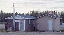
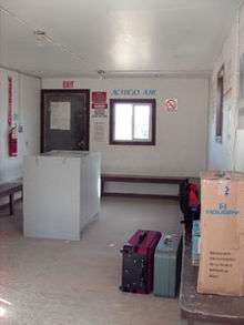
Interior of the Departures building (the left building in the picture on the right). August 2005.
Because Sachigo Lake First Nation is a "dry" community that forbids alcohol, each arriving passenger has their luggage searched in a separate arrivals building to make sure they are not bringing any contraband in with them.
Airlines and destinations
| Airlines | Destinations |
|---|---|
| Perimeter Aviation | Sandy Lake, Winnipeg |
Accidents and incidents
- On 19 January 1986, Douglas C-47A C-GNNA of Austin Airways struck a 150 ft (46 m) high Non-directional beacon tower and crashed at Sachigo Lake Airport.[1]
References
- ↑ "C-GNNA Accident description". Aviation Safety Network. Retrieved 27 July 2010.
External links
This article is issued from Wikipedia - version of the 12/4/2016. The text is available under the Creative Commons Attribution/Share Alike but additional terms may apply for the media files.