Rubha nan Gall
 Rubha nan Gall lighthouse | |
 Argyll and Bute | |
| Location |
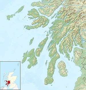
North-East point of the Isle of Mull Argyll and Bute Scotland United Kingdom |
|---|---|
| Coordinates | 56°38′19″N 6°03′58″W / 56.638672°N 6.066241°WCoordinates: 56°38′19″N 6°03′58″W / 56.638672°N 6.066241°W |
| Year first constructed | 1857 |
| Automated | 1960 |
| Construction | brick tower |
| Tower shape | cylindrical tower with balcony and lantern |
| Markings / pattern | white tower, black lantern, ochre trim |
| Height | 18.9 metres (62 ft) |
| Focal height | 17 metres (56 ft) |
| Light source | solar power |
| Range | 10 nautical miles (18.5 km) |
| Characteristic | Fl W 3s. |
| Admiralty number | A4112 |
| NGA number | 4032 |
| ARLHS number | SCO-194 |
| Managing agent | Northern Lighthouse Board[1] |
| Heritage | C-class Listed Building |
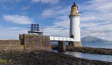
Rubha nan Gall lighthouse is located north of Tobermory on the Isle of Mull. The name means "Stranger's Point" in Scottish Gaelic. It was built in 1857 by David and Thomas Stevenson and is operated by the Northern Lighthouse Board. The lighthouse was automated in 1960 and the nearby former keeper's cottage is a private residence.
In August 2013, the former keeper's cottage, together with 80 acres (32 ha) of land and 1 mile (1.6 km) of shore front, was put up for sale at £225,000. Access is by sea or a 1.5 miles (2.4 km) muddy footpath from Tobermory along the steep wooded coastline. The cottage has no mains electricity, water or sewer connections; instead a private spring supplies water, and solid fuel or gas provide heat and light.
See also
References
- ↑ Rubha nan Gall The Lighthouse Directory. University of North Carolina at Chapel Hill. Retrieved 24 May 2016
- "Listed Building Report: TOBERMORY LIGHTHOUSE RUDHA NAN GALL". Historic Scotland. Retrieved 24 August 2013.
- "4 bedroom cottage for sale, Rubha nan Gall Tobermory, Isle Of Mull, PA75 6PR". Rightmove. Retrieved 24 August 2013.
- "Mull, Rubha nan Gall, Lighthouse". Canmore. Retrieved 24 August 2013.
External links
| Wikimedia Commons has media related to Rubha nan Gall Lighthouse. |

Lighthouse and cottage with view across to Kilchoan on the Ardnamurchan peninsular
This article is issued from Wikipedia - version of the 5/25/2016. The text is available under the Creative Commons Attribution/Share Alike but additional terms may apply for the media files.