Royal Borough of Kensington and Chelsea
| Royal Borough of Kensington and Chelsea | |||
|---|---|---|---|
| London borough, Royal borough | |||
| |||
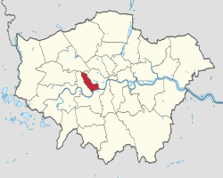
 Kensington and Chelsea shown within Greater London | |||
| Sovereign state | United Kingdom | ||
| Constituent country | England | ||
| Region | London | ||
| Ceremonial county | Greater London | ||
| Status | London borough, Royal borough | ||
| Admin HQ | Kensington | ||
| Created | 1 April 1965 | ||
| Government | |||
| • Type | London borough council | ||
| • Body | Kensington and Chelsea London Borough Council | ||
| • Leadership | Leader & Cabinet (Conservative) | ||
| • Mayor | Cllr James Husband | ||
| • MPs |
Greg Hands (Con) Lady Victoria Borwick (Con) | ||
| • London Assembly | Tony Devenish (Con) AM for West Central | ||
| • EU Parliament | London | ||
| Area | |||
| • Total | 4.68 sq mi (12.13 km2) | ||
| Area rank | 325th (of 326) | ||
| Population (mid-2014 est.) | |||
| • Total | 156,190 | ||
| • Rank | 121st (of 326) | ||
| • Density | 33,000/sq mi (13,000/km2) | ||
| • Ethnicity[1] |
39.3% White British | ||
| • ONS code | 00AW | ||
| Time zone | GMT (UTC0) | ||
| • Summer (DST) | BST (UTC+1) | ||
| Postcodes | NW, SW, W | ||
| Area code(s) | 020 | ||
| Police force | Metropolitan Police | ||
| Website |
www | ||
The Royal Borough of Kensington and Chelsea (often abbreviated to RBKC) is an inner London borough of Royal borough status, to the west of the centre. As the smallest borough in London and the second smallest district in England, this urban area is one of the most densely populated in the United Kingdom.
The borough is immediately to the west of the City of Westminster and to the east of London Borough of Hammersmith and Fulham. It contains major museums and universities in Albertopolis, department stores such as Harrods, Peter Jones and Harvey Nichols, and embassies in Belgravia, Knightsbridge and Kensington Gardens. It is home to the Notting Hill Carnival, Europe's largest. It contains many of the most expensive residential districts in London and even in the world, as well as districts with high levels of social housing and poverty.
The local authority is Kensington and Chelsea London Borough Council. The borough's motto is Quam Bonum in Unum Habitare, which can be roughly translated as 'How good to dwell in unity'.
History
The borough was created in 1965 from the former boroughs of Kensington and Chelsea. Kensington's Royal Borough status was inherited by the new borough. The new borough was originally to be called just 'Kensington' – the inclusion of Chelsea was locally supported.[2]
Districts
The borough includes:
- Albertopolis
- Bayswater (also partly in the City of Westminster)
- Belgravia (also partly in the City of Westminster)
- Brompton
- Chelsea
- Chelsea Harbour (also partly in the London Borough of Hammersmith and Fulham)
- Earl's Court
- Holland Park
- Kensal Green (also partly in Brent)
- Kensington
- Knightsbridge (also partly in the City of Westminster)
- Ladbroke Grove
- North Kensington
- Notting Hill
- South Kensington
- West Brompton
- West Kensington (also partly in the London Borough of Hammersmith and Fulham)
- World's End
See also Kensington and Chelsea parks and open spaces
Demographics
At the 2011 census, the borough had a population of 158,649 who were 71% White, 10% Asian, 5% of multiple ethnic groups, 4% Black African and 3% Black Caribbean. Due to its high French population it has long held the unofficial title of the 21st arrondissement of Paris.[3]
In 2005, the borough had more of its land covered by domestic buildings than anywhere else in England at 19%, over half the national average.[4] It also had the fifth highest proportion of land covered by non-domestic buildings at 12%.[4]
As of 2010, statistics released by the Office for National Statistics showed that life expectancy at birth for females was 89.8 years in 2008–2010, the highest in the United Kingdom. Male life expectancy at birth for the same period was 85.1 years.[5] The figures in 1991–1993 were significantly lower: 73.0 years for males (ranking 301st in the nation) and 80.0 for females (ranking 129th). Further investigation indicates a 12-year gap in life expectancy between the affluent wards of Chelsea (Royal Hospital, Hans Town) and the most northerly wards of North Kensington (Golborne, Dalgarno), which have high levels of social housing and poverty.
The borough has a higher proportion (16.6%) of high earners (over £60,000 per year) than any other local government district in the country.[6] It has the highest proportion of workers in the financial sector and the lowest proportion working in the retail sector.
In December 2006, Sport England published a survey which showed that the borough's residents were the fourth most active in England in sports and other fitness activities. 27.9% of the population participate at least three times a week for 30 minutes.[7]
Figures released in 2013 by London’s Poverty Profile – a joint project between New Policy Institute and Trust for London – found Kensington and Chelsea to have the greatest imbalance between high and low earners. The top quarter earn at least £41 per hour, three and a half times the level of the lowest quarter at £12 per hour or less.[8]
Politics

Two of its more notable council leaders were Nicholas Freeman, from 1977 until 1989, and Sir Merrick Cockell who held the position from 2000 to 2013. The Council has 42 Conservative, 9 Labour and 3 Liberal Democrat councillors. The Labour or Liberal councillors have tended to date to have represented areas of the borough with pockets of economic deprivation; some marginal wards in the borough are concentrated towards the north where north Kensington meets Kilburn, Kensal Rise/Green and Ladbroke Grove. All the wards in Holland Park, Notting Hill, Kensington, South Kensington, and Chelsea are termed under the first past the post electoral system safe seats based on their results since the Council's creation in 1965.
The borough shares a Chief Executive with neighbouring Hammersmith & Fulham, and the two boroughs have combined a number of services and departments with one another and with Westminster City Council.
The borough is divided between two constituencies represented in the House of Commons of the Parliament of the United Kingdom:
- Kensington, held by Lady Victoria Borwick for the Conservative Party, and
- Chelsea and Fulham, held by Greg Hands for the Conservative Party.
At the 2005 General Election, the borough was divided differently:
- Kensington and Chelsea, held by Sir Malcolm Rifkind for the Conservative Party, and
- Regent's Park and Kensington North, held by Karen Buck for the Labour Party.
Rifkind held the Kensington seat until the 2015 General Election when he stood down after becoming embroiled in a scandal, uncovered by a television investigation, over accepting money in return for access to influential British diplomats and politicians..[9]
| From 1885 | From Feb 1974 | From 1997 | From 2010 |
|---|---|---|---|
| Kensington North | Kensington | Part of Regent's Park and Kensington North | Kensington |
| Kensington South | Kensington and Chelsea | ||
| Chelsea | Part of Chelsea and Fulham | ||
Public transport
Underground
The borough has 12 tube stations, on six of the 12 London Underground lines:
with stations at South Kensington, Gloucester Road, Kensington High Street, Earl's Court, Sloane Square, West Brompton, Olympia, Notting Hill Gate, Holland Park, Latimer Road, Knightsbridge, Westbourne Park, Ladbroke Grove, and partly Kensal Green.
Chelsea (SW3, SW10 and partly SW1) has less Underground access than Kensington, the only station within Chelsea being Sloane Square. There are long-term plans for the Chelsea-Hackney line, with a station in the King's Road near Chelsea Old Town Hall, and possibly another at Sloane Square. Its estimated completion is 2022.
National Rail and Overground
Paddington and Victoria are the nearest major railway termini, and National Rail stations in the borough are Kensington (Olympia) and West Brompton, and partly Kensal Green, all both served by the London Overground.
Buses
Many London bus routes pass through the borough, most of them along King's Road, Fulham Road, Kensington High Street and Ladbroke Grove.
Travel to work
In March 2011, the main forms of transport that residents used to travel to work were: underground, metro, light rail, tram, 23.6% of all residents aged 16–74; driving a car or van, 8.2%; on foot, 8.2%; bus, minibus or coach, 8.0%; work mainly at or from home, 7.0%; bicycle, 3.1%; train, 2.1%.[10]
Possible new Crossrail station
The borough council is pushing for an additional Crossrail station in the north of the borough, at Kensal[11] off Ladbroke Grove & Canal Way. A turn-back facility will have to be built not too far west of Paddington, and siting the turn-back at Kensal rather than next to Paddington would provide a frequent service, helping to regenerate the area.[12][13][14] London Mayor Boris Johnson stated that a station would be added if it met three tests: it must not delay construction of Crossrail; it must not compromise performance of Crossrail or any other railway; and it must not increase Crossrail's overall cost. In response, the borough council agreed to underwrite the projected £33 million cost of the station to the extent that section 106 payments from the promoters of property developments expected near the station do not reach this sum.[15] The Council funded a consultancy study, which concluded that in many scenarios a Kensal station would not compromise Crossrail performance. TfL is conducting a feasibility study on the station. The project is supported by local MPs, the residents of the Borough, National Grid, retailers Sainsbury's and Cath Kidston, and Jenny Jones (Green Party member of the London Assembly).[16] It is also supported by the adjoining London Borough of Brent.[17]
Economy

The head office of Daily Mail and General Trust is in the Northcliffe House in Kensington.[18][19] Round Hill Capital has its headquarters in Chelsea.[20]
Sonangol Limited, a subsidiary of the Sonangol Group, has its head office in Merevale House in Kensington.[21]
Religion

The borough has a number of notable churches, including:
- Brompton Oratory – Roman Catholic
- Chelsea Old Church (All Saints) – Church of England
- Holy Trinity Brompton – Church of England
- St Columba's Church, Pont Street – Church of Scotland
- St Luke's Church, Chelsea, Sydney Street – Church of England
- St Mary Abbots – Church of England
- St Sophia's Cathedral – Greek Orthodox Church
- Kensington Temple - Elim Pentecostal Church
It is home to a small Spanish and Portuguese synagogue, several mosques and the Sikh Central Gurudwara in Holland Park. There are two Armenian churches - Saint Sarkis Armenian Church and Church of Saint Yeghiche
According to the 2001 Census, 24% of the borough's population identified themselves as being non-religious or chose not to state their faith.
Featured places

Within the borough there are several of London's tourist attractions and landmarks:
- Brompton Oratory
- Earl's Court
- Harrods
- Imperial College (part)
- Jumeirah Carlton Tower
- Kensington Arcade
- Kensington High Street
- Kensington Palace
- King's Road
- Ladbroke Grove
- Leighton House Museum
- Notting Hill Gate
- Olympia (part)
- Portobello Road
- Royal Albert Hall
- Royal Hospital Chelsea
- Saatchi Gallery
- Sloane Street
- The Science Museum and Natural History Museum
- Victoria & Albert Museum
- Stamford Bridge
Education
Schools

The council's education department finances state schools.[22]
Further education
Universities
- English National Ballet School- in the heart of Chelsea
- Royal College of Art – the main campus is in South Kensington, with the sculpture department in Battersea.
- Royal College of Music
- Imperial College London – the main campus is in South Kensington.
- Heythrop College – a Constituent College of the University of London specialising in Theology & Philosophy
- Richmond, The American International University in London – the secondary campus is in Kensington.
- Fordham University - maintains a campus through a partnership with Heythrop College
Public libraries
Libraries include the Kensington Central Library, Chelsea Library, Kensal Library, Brompton Library, North Kensington Library and the Notting Hill Gate Library.[23]
International relations
The French community
The number of French people living in Britain has increased every year since 1991, according to French government statistics.[24] It jumped by 8,716 in 2006, the biggest gain in at least 20 years. French people live throughout much of London, but particularly in Kensington. There are several French schools, officially classed as independent schools in Britain, as they are not maintained or owned by local councils or the Department for Education: La Petite École Française in west London and the Lycée Français Charles de Gaulle in South Kensington (which is owned and run by the French state) are among them.
Town twinning
The Royal Borough of Kensington and Chelsea is formally twinned with:
See also
References
- ↑ 2011 Census: Ethnic group, local authorities in England and Wales, Office for National Statistics (2012). See Classification of ethnicity in the United Kingdom for the full descriptions used in the 2011 Census.
- ↑ "Chelsea Name Retained: New Decisions on Three Boroughs." The Times. 3 January 1963
- ↑ Global Business. "High earners say au revoir to France". The Daily Telegraph. Retrieved 14 August 2012.
- 1 2 Key Statistics: Dwellings; Quick Statistics: Population Density; Physical Environment: Land Use Survey 2005
- ↑ http://www.swlondoner.co.uk/kensington-chelsea-has-uk-s-highest-life-expectancy/
- ↑ http://money.guardian.co.uk/print/0%2C3858%2C4965695-110144%2C00.html The Guardian
- ↑ http://www.sportengland.org/index/get_resources/research/active_people/active_people_survey_headline_results.htm sportengland.org
- ↑ http://www.londonspovertyprofile.org.uk/indicators/topics/inequality/
- ↑ "Malcolm Rifkind to stand down as an MP at the election after lobbying controversy". www.newstatesman.com. Retrieved 3 June 2015.
- ↑ "2011 Census: QS701EW Method of travel to work, local authorities in England and Wales". Office for National Statistics. Retrieved 23 November 2013. Percentages are of all residents aged 16-74 including those not in employment. Respondents could only pick one mode, specified as the journey’s longest part by distance.
- ↑ "The case for Kensal crossrail". Royal Borough of Kensington and Chelsea. Retrieved 26 June 2011.
- ↑ "Case for a Crossrail station gains momentum" (Press release). Royal Borough of Kensington and Chelsea. 1 July 2010.
- ↑ Bloomfield, Ruth (24 August 2010). "Study to explore adding Crossrail station at Kensal Rise". Building Design. London.
- ↑ "Crossrail at Kensal Rise back on the cards?". London Reconnections (blog). 27 August 2010.
- ↑ "Council to pay for Crossrail station". Evening Standard. London. 25 March 2011.
- ↑ Kensal Crossrail station would 'transform' the area, says deputy mayor. Regeneration + Renewal. 16 May 2011.
- ↑ "Brent backs plans for Kensal Crossrail". Royal Borough of Kensington and Chelsea. 27 September 2011. Retrieved 30 September 2011.
- ↑ "Contacts." Daily Mail and General Trust. Retrieved 6 September 2011. "Northcliffe House 2 Derry Street London W8 5TT Great Britain"
- ↑ Ponsford, Dominic. "Sharing with Mail 'will safeguard future of Independent'." Press Gazette. 28 November 2008. Retrieved 6 September 2011. "Under a deal signed today, the Independent titles will share back office functions with the Daily Mail, Mail on Sunday, Metro and Evening Standard at Northcliffe House in Kensington."
- ↑ "Contact Us." Round Hill Capital. Retrieved on 10 April 2014. "250 Kings Road London SW3 5UE United Kingdom"
- ↑ "Contact." Sonangol Limited. Retrieved 6 August 2011. "Sonangol Limited Merevale House Brompton Place London SW3 1QE United Kingdom."
- ↑ http://www.rbkc.gov.uk/az/az.asp?searchletter=F&orgid=1372 rbkc.gov.uk
- ↑ http://www.rbkc.gov.uk/leisureandlibraries.aspx Royal Borough of Kensington and Chelsea. Retrieved 13 January 2009.
- ↑ IHT – the French making themselves at home in London
- ↑ "British towns twinned with French towns [via WaybackMachine.com]". Archant Community Media Ltd. Archived from the original on 5 July 2013. Retrieved 20 July 2013.
External links
| Wikivoyage has a travel guide for South Kensington-Chelsea. |
| Wikimedia Commons has media related to Royal Borough of Kensington and Chelsea. |
Coordinates: 51°30′N 0°11′W / 51.50°N 0.19°W

