Regent Square (Pittsburgh)
| Regent Square | |
|---|---|
| Neighborhood of Pittsburgh | |
|
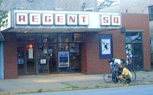
The Regent Square Theatre on Braddock | |
 | |
| Coordinates: 40°25′59″N 79°53′49″W / 40.433°N 79.897°W | |
| Country | United States |
| State | Pennsylvania |
| County | Allegheny County |
| City | Pittsburgh |
| Area[1] | |
| • Total | 0.192 sq mi (0.50 km2) |
| Population (2010)[1] | |
| • Total | 928 |
| • Density | 4,800/sq mi (1,900/km2) |
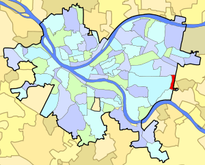
Regent Square is a distinct neighborhood in the East End of Pittsburgh, Pennsylvania. According to the Regent Square Civic Association, it is "a neighborhood that includes portions of the municipalities of Pittsburgh, Edgewood, Swissvale and Wilkinsburg." It is also the name of one of the 65 neighborhoods within the City of Pittsburgh's limits, which leads to some confusion among residents. The neighborhood is split between ZIP codes 15218 and 15221; the part of the neighborhood within the City of Pittsburgh is represented on the City Council by the council seat for District 5 (Southeast Neighborhoods). Despite its division among four municipal governments and three school districts, Regent Square's identity bolstered by an active community association. Geography also helps to give Regent Square a distinct identity: the neighborhood is a roughly rectangular plateau bounded on three sides by the steep valleys of Fern Hollow Creek to the west and Nine Mile Run to the south and east.
The tree-lined neighborhood is situated along both sides of Braddock Avenue between the Parkway East (I-376) and Forbes Avenue. The area of the present neighborhood was owned by a series of local landowners, including Col. Dunning McNair in the late 18th and Judge William Wilkins in the late 19th century. The name Regent Square was apparently bestowed by William E. Harmon of Harmon Realty, who in 1919 acquired most of the present neighborhood, then known as the Devon Plan. First calling it Regent Place, he later changed the name to Regent Square. By the mid-20th century, Regent Square was a quietly prosperous garden suburb characterized by middle and upper-middle income residents, a significant number of whom were managerial or professional employees of the Westinghouse Electric Corporation. The neighborhood at that time had a distinctly Irish ethnic character, still evident in the names of several businesses along Braddock Avenue.
At the turn of the 21st century Regent Square, like much of Pittsburgh's East End, had come to be characterized by a large proportion of upper-middle class professionals associated with the city's medical and educational institutions. These residents share the neighborhood with a significant number of students and younger singles attracted to its proximity to Carnegie Mellon University and the University of Pittsburgh, the 550-acre (2.2 km2) Frick Park, and readily available mass transit to downtown Pittsburgh.
Regent Square's grid street plan and Victorian and 'Tween-Wars architecture, with houses built close to each other and porches close to the tree-lined sidewalks, tend to promote a sense of community rare in less densely built modern suburban neighborhoods. As a result, both residents and visitors often remark on the sense of living in a village, a sense which is accentuated by the geographical isolation of the neighborhood, cut off as it is from surrounding districts by Frick Park to the west and north and the valley of Nine Mile Run to the south.
Community Organizations
Although a small neighborhood, Regent Square is home to a number of active community centers and organizations:
- Regent Square Business, Real Estate, Neighborhood, and Message Boards
- Environmental Charter School at Frick Park
- Frick Park Clay Court Tennis Club
- Nine Mile Run Watershed Association
- Pittsburgh Filmmakers (Regent Square Theater)
- Regent Square Civic Association
- Wilkins School Community Center
- R^2 Athletics Association
Local Libraries
Two libraries reside in adjoining neighborhoods, the C.C. Mellor Memorial Library in Edgewood and the Carnegie Library-Swissvale Branch, which serve as meeting places for various clubs and organizations.
See also
List of Pittsburgh neighborhoods
References
- 1 2 "PGHSNAP 2010 Raw Census Data by Neighborhood". Pittsburgh Department of City Planning PGHSNAP Utility. 2012. Retrieved 28 June 2013. External link in
|publisher=(help)
