Rørvik
| Rørvik | |
|---|---|
| Village | |
|
View of the village | |
 Rørvik  Rørvik Location in Nord-Trøndelag | |
| Coordinates: 64°51′43″N 11°14′14″E / 64.86194°N 11.23722°ECoordinates: 64°51′43″N 11°14′14″E / 64.86194°N 11.23722°E | |
| Country | Norway |
| Region | Trøndelag |
| County | Nord-Trøndelag |
| District | Namdalen |
| Municipality | Vikna |
| Area[1] | |
| • Total | 1.76 km2 (0.68 sq mi) |
| Elevation[2] | 4 m (13 ft) |
| Population (2013)[1] | |
| • Total | 2,949 |
| • Density | 1,676/km2 (4,340/sq mi) |
| Time zone | CET (UTC+01:00) |
| • Summer (DST) | CEST (UTC+02:00) |
| Post Code | 7900 Rørvik |

Rørvik is a port village in the municipality of Vikna in Nord-Trøndelag county, Norway. The village also serves as the administrative centre of the municipality. It is on the eastern side of the Vikna archipelago on the island of Inner-Vikna. The 1.76-square-kilometre (430-acre) village has a population (2013) of 2,949. The population density of the village is 1,676 inhabitants per square kilometre (4,340/sq mi).[1]
There are several museums in Rørvik and a hotel. Telenor Mobil is an important employer, as is public service, fishing, and commercial salmon fish farming. Rørvik is also home to the Ytre Namdal Upper Secondary School and Rørvik Church.
Geography
The town is located in the northwestern part of Nord-Trøndelag county in central Norway, approximately 200 kilometres (120 mi) north of the city of Trondheim (320 kilometres or 200 miles by road). Rørvik lies at the eastern part of the Vikna archipelago, on the Inner-Vikna island at the western shore of the Nærøysundet strait, facing the mainland on the eastern shore of the strait. The climate is maritime, and many private gardens have plum and apple trees even here at a latitude of 65°N.
History
This area was early settled, and there are several prehistoric burial mounds. Among the rocky slopes and cliffs on the islands are many surprisingly lush lowland fields, and farming and fishing were the traditional ways of life, as they partly still are. The last decades have seen many people moving to Rørvik from other parts of the archipelago.
Transportation
Rørvik is a port of call of the Hurtigruten coastal steamer, and the northbound and southbound ships meet in Rørvik in the evening. Vikna has been accessible by car from the mainland since 1981 when the Nærøysund Bridge and Marøysund Bridge on Norwegian County Road 770 was completed. The speedboat Namdalingen runs three times daily to Namsos, the regional center. Rørvik Airport, Ryum is located just south of Rørvik, and it serves the Vikna/Nærøy area.[3]
Media gallery
 Rørvik, July 28, 2006
 Rørvik Church
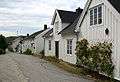 Torggata (street)
References
- 1 2 3 Statistisk sentralbyrå (1 January 2013). "Urban settlements. Population and area, by municipality.".
- ↑ "Rørvik" (in Norwegian). yr.no. Retrieved 2011-10-04.
- ↑ Store norske leksikon. "Rørvik" (in Norwegian). Retrieved 2011-10-04.
External links
- Norveg museum - Norway's coastal heritage from the ice age to the present
- Namdalskysten - A tourist site about the municipalities on the coast of Nord-Trøndelag