Provincial Highway 66 (Taiwan)
| ||||
|---|---|---|---|---|
 | ||||
| Route information | ||||
| Maintained by Directorate General of Highways | ||||
| Length: | 27.200 km[1] (16.901 mi) | |||
| Major junctions | ||||
| West end: |
| |||
| East end: |
| |||
| Highway system | ||||
| ||||
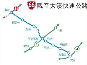
Provincial Highway 66 (Chinese: 台66線) is an expressway, which begins in Guanyin District, Taoyuan City on Provincial Highway 61 and ends in Daxi District, Taoyuan City, on County Road 112A.
Major urban areas along the route
Major intersections
| County | Location | km[1] | mi | Exit | Name | Destinations | Notes |
|---|---|---|---|---|---|---|---|
| Guanyin | 0.000 | 0.000 | 0 | Guanyin | |||
| 1.018 | 0.633 | ||||||
| 2.038 | 1.266 | TR 89 – Guanyin, Baosheng | |||||
| TR 94 – Guanyin, Baosheng | |||||||
| 5.111 | 3.176 | 5 | Guanyin 1 | Interchange | |||
| 7.185 | 4.465 | TR 84 – Xinpo, Xinwu | |||||
| Xinwu | 8.458 | 5.256 | TR 82 – Fuyuan, Xinwu | ||||
| 10.800 | 6.711 | 10 | Xinwu | Interchange | |||
| 12.731 | 7.911 | TR 81 – Touzhou, Laofandian | |||||
| 13.008 | 8.083 | TR 79 – Touzhou, Yangmei | |||||
| Yangmei | 15.221 | 9.458 | TR 102 – Xinrong, Gaorong | ||||
| 15.221 | 9.458 | West end of freeway | |||||
| Pingzhen | 17.738 | 11.022 | 18 | Pingzhen System | |||
| 18.702 | 11.621 | 19 | Pingzhen 1 | Eastbound exit and westbound entrance | |||
| 20.253 | 12.585 | 20 | Pingzhen 2 | ||||
| 23.181 | 14.404 | 23 | Pingzhen 3 | ||||
| Daxi | 27.200 | 16.901 | 27 | Daxi End | |||
| 1.000 mi = 1.609 km; 1.000 km = 0.621 mi | |||||||
Notes
The elevation of the main line between Provincial Highway 31 and Township Road 102 is now under construction and will be completed on June, 2014.
References
- 1 2 "Expressway Mileage Chart" (XLS file) (in Chinese). Directorate General of Highways. Retrieved 29 March 2014.
This article is issued from Wikipedia - version of the 11/2/2015. The text is available under the Creative Commons Attribution/Share Alike but additional terms may apply for the media files.
