Pritchard, British Columbia
| Community of Pritchard | |
|---|---|
| Community | |
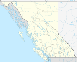
 Location of Pritchard in British Columbia | |
| Coordinates: 50°41′11″N 119°49′8″W / 50.68639°N 119.81889°WCoordinates: 50°41′11″N 119°49′8″W / 50.68639°N 119.81889°W | |
| Country |
|
| Province |
|
| Region | Thompson Country |
| Regional district | Thompson-Nicola |
| Incorporated | Unincorporated |
| Area | |
| • Total | 13.05 km2 (5.04 sq mi) |
| Elevation | 360 m (1,180 ft) |
| Population (2001) | |
| • Total | 2,061 |
| • Density | 160/km2 (410/sq mi) |
| Time zone | PST (UTC-8) |
| Postal code span | V0E 2P0 |
| Highways | 1 |
| Waterways | South Thompson River |
Pritchard is a small community located in the Interior of British Columbia, Canada. It has a population of roughly 2,000, and its main industries are farming and tourism. Pritchard is located on the Trans-Canada Highway (HWY 1) between Kamloops, British Columbia and Chase, British Columbia, near the Hwy 97 - Hwy 1 Intersection.
Pritchard was named after Walter Percy Pritchard who purchased 160 acres from John G. Fawcett on September 1, 1907, along the South Thompson River east of the present bridge. He later built the Hotel Pritchard on the property and established the community's first post office there. Needing a name, he decided to lend it his own last name.
References
External links
This article is issued from Wikipedia - version of the 3/21/2014. The text is available under the Creative Commons Attribution/Share Alike but additional terms may apply for the media files.
