Premier, British Columbia
| Premier | |
|---|---|
| Abandoned town | |
 Premier Location of Premier in British Columbia | |
| Coordinates: 56°03′00″N 130°01′00″W / 56.05000°N 130.01667°WCoordinates: 56°03′00″N 130°01′00″W / 56.05000°N 130.01667°W | |
| Country |
|
| Province |
|
| Area code(s) | 250, 778 |

Premier was a large gold mining camp in British Columbia, Canada some 18 miles from Stewart. It ran from the years 1918 to 1953 and was a large employer in the area. Huge bunkhouses, generators, concentrators, machine and cook houses sat on the hillside. A road provided access to the area, snowfall pending. Horses and cat tractors were used.
Strangely Premier was closer to Hyder, Alaska, United States some 14 miles away, but the mine was in Canadian territory. The international aspects of the operation provided some interesting details on men's entertainment. Liquor was legal in Canada, while bawdy houses were not. Hyder did a lively business in providing entertainment.
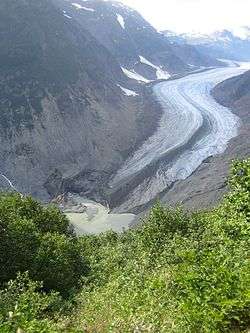
The mine was reopened as an open pit in 1987 by Westmin Resources. The Granduc copper mine is nearby, further north on a gravel based road; and there are other properties—BC Silver, Newmont, and Skyhawk. The Granduc Mine is about 4 miles up the Granduc Road and above the treeline, partly under a glacier.
See also
- Alaska Panhandle
- Eskay Creek
- Granduc Mine British Columbia
- Salmon Glacier
- Stikine River
- Unuk River
- Hyder, Alaska
- Stewart, British Columbia
References
- Silbank Premier Mine - BC Govt MINFILE Mineral Inventory Record Summary
- Alaska-Premier Mine - BC Govt MINFILE Mineral Inventory Record Summary
- Upper Tau showing - BC Govt MINFILE Mineral Inventory Record Summary
- Canada GeoNames Database entry