Port St Mary railway station
Port St. Mary Railway Station Stashoon Phurt Le Moirrey | |
|---|---|
| Isle of Man Railway Company | |
 | |
| Location | Station Road, IM8 4FW. |
| Coordinates | 54.081°N 4.743°W |
| Owned by | Isle Of Man Railways |
| Line(s) | Port Erin Line |
| Platforms | One, Raised (One Goods) |
| Tracks | Running Line & Siding |
| Construction | |
| Structure type | Station & Goods Shed |
| Parking | Dedicated, At Rear |
| Disabled access | Yes |
| History | |
| Opened | 1 August 1874 |
| Closed | Seasonally Since 1965 |
| Rebuilt | 1898 / 1901 |
| Previous names | Isle Of Man Railway Co. |
| Traffic | |
| Passenger Only (Since 1969, Goods Previously) | |
| Services | |
|
Toilets, Waiting Room, Booking Facilities | |
Port St. Mary Railway Station is a station in Port St Mary in the south of the Isle of Man and is served by the Isle of Man Railway, having first opened in 1874 when the line to nearby Port Erin was completed. It forms part of the sole remaining section of the railway which once covered a network of some 46 miles across the island.
Origins
When first opened the station was complemented by a wooden station structure with corrugated iron roof similar to that which still exists at Santon Santon but at around the turn of the twentieth century this was replaced by the building which remains today. The village only received a station at all following public outcry when the proposed route was announced, with a request to deviate the line also being submitted, This was not carried out however, resulting in today's station being some distance from the heart of the village it serves. A small timber goods shed was provided in 1880 being of similar style to those elsewhere on the route.
Hollywood
The goods shed was used as the set for Burnett Stone's workshop on Muffle Mountain for the filming of Thomas and the Magic Railroad along with several other railway locations. The engines of the Isle of Man Railway however did not appear in the film. For filming purposes the interior of the shed was dressed to become a workshop where the engine Lady resided; at this time the fabric of the building was also restored, with new external doors and improved lighting. The exterior also saw use in 2001 when it was used for a night shoot for the Channel Four production of Cinderella which also featured the locomotive Caledonia, then carrying the deep blue livery. Sequences for various other productions have used the station in more recent times, these include The Ginger Tree in 1988, The Brylcreem Boys in 1999 and various episodes of documentaries featuring the island, notably Wish You Were Here...
The Building

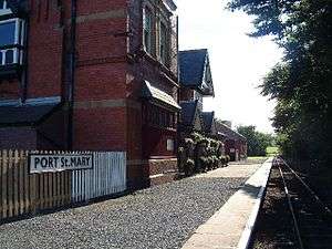
The impressive two-storey station building would lead the casual observer to think it to be the railway's terminus which is in fact just under a mile away at Port Erin; it was constructed by a local firm in 1898 to serve the large demand of tourists for whom the village was a popular resort. It is the only "proper" station on the line to not have a passing loop, owing to its close location to the southern terminus. The station remains under the ownership of the railway but has been largely out of use. In 1980 the station was converted by the company Campamarina for use in conjunction with their Trailblazers holiday scheme and was used as a hostel (the buildings at Castletown Station were similarly treated at the same time). At this time the railway passed over the use of the whole building, and the station staff were subsequently housed in a garden shed-type structure on the platform. When the usage change, the canopy structure that runs parallel to the platform was bricked in and remains so today, although latterly the station master is once again housed in the building itself, albeit in a smaller office using part of the original ladies' waiting room. The ground floor consists of a large reception room with open fireplace and toilet facilities; formerly there was a refreshment room here too. The upper storey is served by one staircase and has a row of bedrooms running from a corridor which runs along the railway side of the building. Today the upper storey lies empty.
Station Environs

The station, despite having no passing/run-round facilities, does boast a substantial goods shed served by a dedicated siding which was lifted in the 1979 but reinstated in 2002 at the same time as the whole of the permanent way was replaced along the line. When reinstated, the siding was not connected to the imposing goods shed, however in the winter of 2007/2008 rail connections were restored. A second siding which once served the rear of the shed was removed in 1974 and has not been replaced. Being some distance from the village, the nearest point of interest is the Station Hotel which lies behind the station. Also to the rear was the gasworks (closed and demolished in 2012) followed by a walk of some half mile before reaching the outskirts of the village. The first building of interest close to the station is the local primary school Schooil Purt Le Moirrey which was only established in the year 2000. Thereafter lies the village proper with its lines of shop fronts leading down to the harbour. A crossroads close to the station directs traffic either to the village, the coast at Gansey Bay or the folk museum at Cregneash and The Sound (latterly styled as Lands End Of Mann.
Today

In keeping with current policy, the station received new bi-lingual nameboards in 2008 in a standard maroon and cream colour scheme (the previous colouring here had been black, white and grey). On the northerly side of the level crossing there is a gatekeepers cottage which is now a private dwelling. To the rear of the station is the Station Hotel. From August 2014 the station became unmanned for the remainder of the railway's season with passengers boarding and alighting purchasing tickets elsewhere. Train guards now operate the barriers which protect the line from the adjacent road to the village. During special events on the railway the station has been used as a drop off point for shuttle buses to Cregneash Folk Museum for Island At War each summer and the Heritage Open Days that are staged by Manx National Heritage each October. The goods shed remains in railway hands and is used for storage purposes only, housing one of three remaining closed vans until the winter of 2013 when this was moved to Port Erin to form part of a new display in the railway museum. The goods yard is used to store other railway items, notably the former railings from Port Erin Station. The station remains a popular drop off point for walkers who then use the coastal footpath beyond to reach Port Erin and return by rail in the summer months. It is also the nearest station for the national folklore museum to which a limited bus service is operated.
Recent Developments

Having been largely unoccupied for several years, the station masters' accommodation was relocated in the late 1990s to the building itself and the garden shed structure was removed. The building itself has been the subject of several restoration/conversion attempts but all of these have been fruitless to date. In 2008 a local developer is understood to have received permission to convert the building into apartments, whilst retaining the frontage of the platform area, removing the bricked-up canopy added in 1979 and restoring much of the charm of the railway-oriented site. This plan never came to fruition and the buildings were again placed on the market in 2012, and subsequently sold subject to planning, for conversion to offices. This application was denied on the grounds of insufficient parking and to date the station building lies empty while the shed remains in railway hands and used for storage. The station is currently up for sale and the former gasworks land to the rear is proposed to become another residential area following the closure of the works in 2012. The station remained manned by railway staff until the summer of 2014 and it is understood it will become unmanned from the 2015 season to reduce the railway's operating costs.
Routes
| Preceding station | Isle of Man Railway | Following station | ||
|---|---|---|---|---|
| Port Erin | Port Erin Line | Level |
See also
References
- James I.C. Boyd Isle Of Man Railway, Volume 3, The Routes & Rolling Stock (1996) ISBN 0-85361-479-2
- Norman Jones Scenes from the Past: Isle of Man Railway (1994) ISBN 1-870119-22-3
- Robert Hendry Rails in the Isle of Man: A Colour Celebration (1993) ISBN 1-85780-009-5
- A.M Goodwyn Manx Transport Kaleidoscope, 2nd Edition (1995)
External links
Coordinates: 54°04′52″N 4°44′35″W / 54.081°N 4.743°W