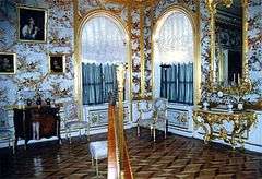
Peterhof Grand Palace
Coordinates: 59°53′N 29°54′E / 59.883°N 29.900°E

The Peterhof Grand Palace (Russian: Большой Петергофский дворец) is actually a part of palaces and gardens, laid out on the orders of Peter the Great. These Palaces and gardens are sometimes referred as the "Russian Versailles". The palace-ensemble along with the city center is recognized as a UNESCO World Heritage Site.

The largest of Peterhof's palaces looks truly imposing when seen from the Lower or Upper Gardens, but in fact it is quite narrow and not overly large. Of its approximately thirty public rooms, several deserve mention.
The Chesma Hall is decorated with twelve large paintings of the Battle of Chesma, a stunning naval victory of the Russo-Turkish War, 1768-1774. These were painted between 1771 and 1773 by the German artist Jacob Philipp Hackert. His first renderings of the great battle scenes were criticized by witnesses as not showing realistically the effect of exploding ships — the flying timbers, great flames, smoke, and fireballs. Catherine II assisted the artist by exploding a frigate in the harbor of Livorno, Italy, for the benefit of Hackert, who had never seen a naval battle firsthand. Hackert also did not research the actual positions of the Russian and Turkish forces during the battle, so the scenes depicted are somewhat fanciful, but do effectively convey drama and destruction of naval warfare.
The East and West Chinese Cabinets were decorated between 1766 and 1769 to exhibit objects of decorative art imported from the East. The walls were decorated with imitation Oriental patterns by Russian craftsmen, and hung with Chinese landscape paintings in yellow and black lacquer.
Another room, positioned at the center of the palace, bears the name of the Picture Hall. Its walls are almost entirely covered by a series of 368 paintings, mostly of variously dressed women, differing in appearance and even age, yet most were drawn from a single model. These were purchased in 1764 from the widow of the Italian artist P. Rotari, who died in St. Petersburg.
External links
| Wikimedia Commons has media related to Grand Peterhof Palace. |
- Pictures of Peterhof - includes Lower and Upper Garden, the Grand Cascade and Palace from Sergey Sorokin - private guide
- Map of Kronstadt in Russian and English showing the central Island of the Kronstadt fortifications and Naval yard that Peter the Great constructed across the shallow Gulf of Finland to control access by water to St. Petersburg after his armed forces took the area from Sweden in 1703. Peter built Peterhof on the southern shore with a clear view of the Kronstadt fortifications and Naval yard.
- Interactive satellite view map of Kronstadt, Peterhof, and St. Petersburg. The Kronstadt Island harbor that Peter the Great built on what was Kotlin Island is in the middle of the Gulf of Finland. The Kronstadt fortifications in shallow water stretch east and south from Kronstadt Island. Peterhof ("Petrodvorets" on this map) is southeast of Kronstadt Island on the shore. St. Petersburg is to the east on the River Neva.
- Peterhof - official Website, available in Russian or English.
- Peterhof (Petrodvorets) - a Gardens Guide review
- Photoalbum 1024x768
- The Grand Palace. Photoalbum 1024x768
Further reading
- King, Greg (2006). The Court of the Last Tsar (hardback). Hoboken: John Wiley & Sons. pp. 559 pages. ISBN 978-0-471-72763-7.

