Panjgur District
| Panjgur | |
|---|---|
| District | |
| Panjgur District | |
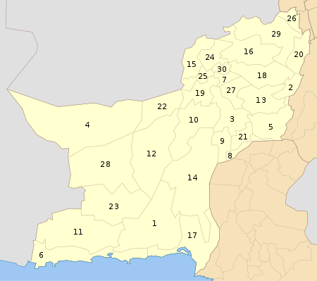
 Map of Balochistan with Panjgur District highlighted | |
| Country | Pakistan |
| Province | Balochistan |
| Headquarters | Panjgur |
| Government | |
| • Current Member of Provincial Assembly | Rehmat Baloch (NP), Haji Islam Baloch (NP) |
| Area | |
| • Total | 16,891 km2 (6,522 sq mi) |
| Population (2005-Projection) | |
| • Total | 243,149 |
| • Density | 14.4/km2 (37/sq mi) |
| Time zone | PST (UTC+5) |
| Area code(s) | 0855 |
| Number of Tehsils | 3 |
| Website |
panjgur |
Panjgur (پنجگور) is a district in the west Balochistan province of Pakistan. Panjgur was one of three districts of Makran District until 1 July 1977, when the district became a part of Makran Division. The other two districts of Makran Division are Kech (Turbat) and Gwadar. Chitkan is the district headquarter. Panjgur has sixteen (16) Union Councils.
Panjgur (literally: Five Graves) is home to several archaeological sites, including centuries-old tombs, an old dam called Band-e-Gillar, remnants of a fort at Khudabadan (the historical fort of Nawab Kharan) and some remnants of the old port of Issai. The seasonal Rakshan River flows right in the middle of Panjgur, dividing it into two parts, the northern and southern Panjgur.
Etymology
In Iranian languages "panj" means "five" and "gor" means "graves". There are five popular graves in this district, which give it the name Panjgur or Panjgor.
Administrative divisions
The district is administratively subdivided into three tehsils which contain a total of 16 Union Councils:[1]
Education
In Panjgur, there are forty-eight primary schools (40 for girls, 8 for boys), 18 middle schools (3 for girls), 26 High schools (16 for male and 10 for female), a teacher training College (Government College of Elementary Education Panjgur), a cadet college, Inter college for Girls, Degree College for girls, a degree college for boys and there are some new private colleges (Oxford Public School Tasp Panjgur, The Oasis School Panjgur and Cambridge Academy Panjgur). Private schools operating in Panjgur have faced attacks from radical Islamic groups for sending girls to co-ed institutions.
Demographics
The population is about 480,001. Over 99% of people in the area are Muslims. Balochi is the local language. Major tribes are Muhammad Hassani, Yallanzai(Rind), Kenagzai(Rind),Halazai, Mullazai(Rind), Sanjrani, Kashani, Gichki, Badini, Reki, Balochzai, Nosherwani, Shahwani, Rodini, Zahrozai, Sorwani,Raees etc.
Notable people
- Mir Abdul Rehman, ex chairmen Panjgur distict from 1965 to 1970
- Malik Siraj Akbar, U.S.-based journalist
Economy
The primary occupation is agriculture, revolving around dates, fishing and poultry. While being a border city a lot of people have started doing their own business.
Transport
Panjgur Airport (IATA: PJG, ICAO: OPPG) is a domestic airport. Its short runway stretches only 1524 meters. PIA started flights to Sharjah in 2013 but these have been suspended by PIA. People in Panjgur normally travel by buses to bigger cities like Quetta and Karachi.
Geography
The towns within the Panjgur District are Tasp Chitkan, Issai, Kallag, Paroom, Washbood, Gramkan, Sand-e-sir, Sarawan, Khudabadan, Tar-Office, Sarikoran, Bonistan, Hiraap, Sare-kalat and Surdoo. During the British Raj, the British Army used Tar-Office as the headquarters of Makran.
Many small rivers cross Panjgur. The main ones are the Rakshan, Niwan and Gwargo and piskol as well is known in Panjgur.
References
- ↑ "Tehsils & Unions in the District of Panjgur – Government of Pakistan". Archived from the original on 26 March 2012.
External links
| Wikimedia Commons has media related to Panjgur District. |
Coordinates: 26°40′N 64°15′E / 26.667°N 64.250°E
