Ogōri, Fukuoka
"Ogori" redirects here. For the former town in Yamaguchi Prefecture, Japan, see Ogori, Yamaguchi.
| Ogōri 小郡市 | ||
|---|---|---|
| City | ||
|
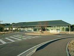
Kyushu Historical Museum | ||
| ||
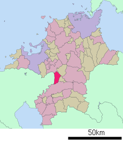
 Location of Ogōri in Fukuoka Prefecture | ||
 Ogōri Location in Japan | ||
| Coordinates: 33°24′N 130°33′E / 33.400°N 130.550°ECoordinates: 33°24′N 130°33′E / 33.400°N 130.550°E | ||
| Country | Japan | |
| Region | Kyushu | |
| Prefecture | Fukuoka Prefecture | |
| Government | ||
| • Mayor | Masatomo Hirayama (since May 2005) | |
| Area | ||
| • Total | 45.50 km2 (17.57 sq mi) | |
| Population (January 1, 2012) | ||
| • Total | 59,296 | |
| • Density | 1,303.21/km2 (3,375.3/sq mi) | |
| Symbols | ||
| • Tree | Cinnamomum camphora | |
| • Flower | Wisteria floribunda | |
| • Bird | Heron | |
| Time zone | Japan Standard Time (UTC+9) | |
| City hall address |
255-1 Ogori, Ogori-shi, Fukuoka-ken 838-0198 | |
| Website |
www | |
Ogōri (小郡市 Ogōri-shi) is a city located in Fukuoka Prefecture, Japan. The city was founded on April 1, 1972.
As of January 31, 2012, the city has an estimated population of 59,296, with 22,059 households and a population density of 1,303.21 persons per km2. The total area is 45.50 km2.
It is bounded by Kurume to the south, Saga Prefecture to the east, Chikushino to the north, and Chikuzen, Tachiarai and what used to be Kitano to the west.
It has seven stations on the Nishitetsu Tenjin Ōmuta Line.
Attractions
Notable residents
External links
| Wikimedia Commons has media related to Ogōri, Fukuoka. |
- Ogōri City official website (Japanese)
This article is issued from Wikipedia - version of the 3/17/2016. The text is available under the Creative Commons Attribution/Share Alike but additional terms may apply for the media files.
