North-Western Provinces
| North-Western Provinces | |||||
| Province of India under Company rule (till 1858) India under the British Raj (from 1858) | |||||
| |||||
 | |||||
| Capital | Agra, Lucknow, Allahabad | ||||
| History | |||||
| • | Established | 1836 | |||
| • | Disestablished | 1902 | |||
| Area | |||||
| • | 1835 (?) | 9,479 km2 (3,660 sq mi) | |||
| Population | |||||
| • | 1835 (?) | 4,500,000 | |||
| Density | 474.7 /km2 (1,229.6 /sq mi) | ||||
| Today part of | | ||||
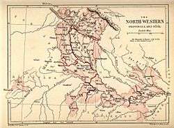
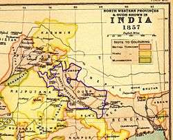
The North-Western Provinces was an administrative region in British India. The North-Western Provinces succeeded the Ceded and Conquered Provinces and existed in one form or another from 1836 until 1902, when it became the Agra Province within the United Provinces of Agra and Oudh (or U.P.).[1] Allahabad served as its capital in 1858 when it also became the capital of India for a day.[2]
Area
The province included all divisions of the present-day state of Uttar Pradesh with the exception of the Lucknow Division and Faizabad Division of Awadh.[1] Among other regions included at various times were: the Delhi Territory, from 1836 until 1858, when the latter became part of the Punjab Province of British India; Ajmer and Merwara, from 1832 and 1846, respectively, until 1871, when Ajmer-Merwara became a minor province of British India; and the Saugor and Nerbudda Territories from 1853 until 1861, when they were absorbed into the Central Provinces.[1][3]
Administration
The North Western Provinces was governed by a Lieutenant-Governor, who was appointed by the East India Company from 1836 to 1858, and by the British Government from 1858 to 1902.[1]
In 1856, after the annexation of Oudh State, the North Western Provinces became part of the larger province of North Western Provinces and Oudh. In 1902, the latter province was renamed the United Provinces of Agra and Oudh; in 1904, the region within the new United Provinces corresponding to the North Western Provinces was renamed the Agra Province.[4]
See also
- List of Chief Commissioners of Oudh
- List of Lieutenant Governors of the North-Western Provinces
- List of Lieutenant Governors of the North-Western Provinces and Chief Commissioners of Oudh
- Company rule in India
- British Raj
- United Provinces of Agra and Oudh

Notes
- 1 2 3 4 Imperial Gazetteer of India vol. XXIV 1908, p. 158
- ↑ Ashutosh Joshi (1 Jan 2008). Town Planning Regeneration of Cities. New India Publishing. p. 237. ISBN 8189422820.
- ↑ Encyclopædia Britannica
- ↑ Imperial Gazetteer of India vol. V 1908, p. 72
References
- Administration of the North-Western Provinces and Oudh, April 1882 – November 1887, Allahabad: Government Press, North-Western Provinces and Oudh, 1887, retrieved 1 August 2011
- Bayly, C. A. (1988), Rulers, Townsmen and Bazaars: North Indian Society in the Age of British Expansion, 1770–1870, Cambridge University Press Archive, ISBN 978-0-521-31054-3, retrieved 1 August 2011
- Government of India. Legislative Dept (1892), The N.-W. provinces and Oudh code: consisting of the Bengal regulations and the local acts of the Governor General in council in force in the North-Western provinces and Oudh, the acts of the Lieutenant-Governor of the North-Western provinces and Oudh in council, the regulation made under 33 Vict., Cap. 3 for the Tarai, and lists of the enactments which have been scheduled in force in, or extended to, the scheduled districts of the North-Western provinces by notification under the scheduled districts act, 1874; with a chronological table and an index, Calcutta: Office of the Superintendent of Government Printing, India, retrieved 1 August 2011
- Imperial Gazetteer of India vol. V (1908), Abāzai to Arcot ("Agra Province" pp. 71–72), Published under the authority of His Majesty's Secretary of State for India in Council, Oxford at the Clarendon Press. Pp. viii, 1 map, 437.
- Imperial Gazetteer of India vol. XXIV (1908), Travancore to Zīra ("United Provinces" pp. 132–276), Published under the authority of His Majesty's Secretary of State for India in Council, Oxford at the Clarendon Press. Pp. vi, 1 map, 437.
Coordinates: 25°27′N 81°51′E / 25.45°N 81.85°E