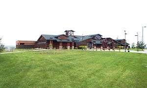
North Dakota Lewis and Clark Interpretive Center

The North Dakota Lewis and Clark Interpretive Center, operated by the Lewis & Clark Fort Mandan Foundation, interprets the history of the Lewis and Clark Expedition, with a special focus on the winter they spent at Fort Mandan.[1] It opened in 1997 and overlooks the Missouri River outside of Washburn, North Dakota (38 miles north of Bismarck, North Dakota's capital).
The center also interprets other aspects of North Dakota history, including the farming-based cultures of the Mandan and Hidatsa nations, the fur trade at Fort Clark Trading Post State Historic Site, Prince Maximilian of Wied-Neuwied's expedition through the area in the 1830s, and later agriculture in the state.[2]
The Center also includes a museum store, temporary exhibits, an events facility, and a research library. It is attached to a highway rest stop serving Highways 83 and 200A.[3][4][5] There are images on display by Karl Bodmer, a Swiss artist who traveled to North Dakota in 1833 with Prince Alexander Maximilian of Wied, Germany.
Just over two miles from the Interpretive Center, Fort Mandan has been reconstructed. It was the Corps of Discovery's wintering post from 1804-1805. The Lewis & Clark Fort Mandan Foundation offers tours of the fort year-round as well as daily interpretive programs.
See also
- Lewis and Clark State Park is situated on one of the upper bays of Lake Sakakawea, 19 miles (31 km) southeast of Williston, North Dakota
External links
- North Dakota Lewis & Clark Interpretive Center website
- LewisAndClarkTrail.com – North Dakota Lewis & Clark Interpretive Center
References
- ↑ http://www.fortmandan.com/default.asp
- ↑ http://www.fortmandan.com/educational/
- ↑ http://www.dot.nd.gov/divisions/maintenance/visitor-centers.htm
- ↑ http://todaysgiving.com/business-community/choosing-an-expanded-mission-versus-a-managed-decline/
- ↑ http://www.fortmandan.com/plan/lewis-and-clark-interpretive-center
Coordinates: 47°18′04″N 101°02′30″W / 47.30111°N 101.04167°W