Ocean Parkway (Brooklyn)
| Ocean Parkway | |
|---|---|
| Route information | |
| Maintained by NYSDOT and NYCDOT | |
| Length: | 4.86 mi[1] (7.82 km) |
| Major junctions | |
| South end: | Sea Breeze Avenue / Surf Avenue in Brighton Beach |
| North end: | Prospect Expressway / Church Avenue in Kensington |
| Highway system | |
|
Ocean Parkway | |
|
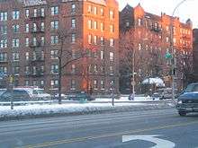
Ocean Parkway runs through Brooklyn | |
| Built | 1874–76 |
| Architect | Frederick Law Olmsted; Calvert Vaux |
| NRHP Reference # | 83001697[2] |
| Added to NRHP | September 8, 1983 |
Ocean Parkway is a 4.86-mile (7.82 km) boulevard in the west-central portion of the New York City borough of Brooklyn. It is inventoried by the New York State Department of Transportation (NYSDOT) as New York State Route 908H (NY 908H), an unsigned reference route.[3]
Route description
Ocean Parkway extends over a distance of about five miles (8 km), running almost north to south from the vicinity of Prospect Park to Brighton Beach. The parkway runs roughly parallel to Coney Island Avenue, an important commercial avenue several blocks to the east. It consists of a central bidirectional avenue of seven lanes (the middle lane is for left turns or a painted median), two small parallel side streets, and two medians with trees, benches, and pedestrian paths. The west median, part of the Brooklyn–Queens Greenway, also has a bike path.
History

Frederick Law Olmsted and Calvert Vaux (who were also responsible for Central Park, Prospect Park, and Eastern Parkway) suggested Ocean Parkway to Brooklyn park commissioners in reports prepared during the 1860s. They drew up a plan for the parkway, inspired by boulevards in Berlin and Paris (such as the present Avenue Foch). In 1868 the land was acquired by the City of Brooklyn; work began in 1874 and was completed in 1880. The resulting parkway is similar to Eastern Parkway, with a central roadway, and complementary grassy median-pedestrian path, and commercial road on the periphery, with a total width of 210 feet (64 m). Trees, playing tables, and benches line the pedestrian path and boulevard. The parkway begins at Park Circle (now known as Machate Circle[4] in honor of NYPD Officer Robert Machate) at the southern entrance of Prospect Park, and passes through Windsor Terrace and what is present-day Kensington. The Prospect Expressway, built in the 1950s, replaced the northernmost half-mile of the parkway, and thanks to a local activist named Arline Bronzaft the parkway was designated a landmark by the city in 1975 to prevent any additional alterations.
The pedestrian path was split in 1894 to create the first bike path in the United States. Around 1900, homes were constructed along the perimeter of the parkway, and during World War I, many mansions were built. Buyers came to Ocean Parkway from Bedford-Stuyvesant, Brooklyn Heights, and Bushwick. In the 1920s, apartment complexes and one- and two-family homes were constructed; the northernmost portion of the parkway became the site of luxurious, elevator-equipped apartment buildings.
Apartments began to replace older homes in the vicinity of the parkway after World War II. Horse racing took place on the parkway until 1908, when a ban on open betting took effect. Until the parkway zoning was changed and restoration was carried out in the 1970s, bridle paths existed as well. The bridle paths were on the eastern side of Ocean Parkway; equestrians could rent horses near Prospect Park and ride them on Ocean Parkway as far as Coney Island. Although one can still rent horses at the nearby Kensington Stables, the bridle paths on Ocean Parkway have since been paved over and are no longer in use.
Major intersections
The entire route is in New York City borough of Brooklyn.
| Location | mi[1] | km | Destinations | Notes | |
|---|---|---|---|---|---|
| Brighton Beach | 0.00 | 0.00 | Sea Breeze Avenue / Surf Avenue | At-grade intersection | |
| 0.56 | 0.90 | Exit 7 (Belt Parkway) | |||
| Gravesend | 2.13 | 3.43 | Kings Highway | ||
| Kensington | 4.86 | 7.82 | Church Avenue | Access via service roads only | |
| 4.86 | 7.82 | Continuation beyond Church Avenue | |||
| 1.000 mi = 1.609 km; 1.000 km = 0.621 mi | |||||
See also
.svg.png) New York Roads portal
New York Roads portal
References
- 1 2 "2011 Traffic Volume Report for New York State" (PDF). New York State Department of Transportation. September 25, 2012. pp. 258–259. Retrieved April 29, 2013.
- ↑ National Park Service (2007-01-23). "National Register Information System". National Register of Historic Places. National Park Service.
- ↑ New York State Department of Transportation (January 2012). Official Description of Highway Touring Routes, Bicycling Touring Routes, Scenic Byways, & Commemorative/Memorial Designations in New York State (PDF). Retrieved February 16, 2012.
- ↑ NYCDPR: Ocean Parkway
External links
| Wikimedia Commons has media related to Ocean Parkway (Brooklyn). |
- NYC Parks and Recreation Ocean Parkway Page
- "Traffic Comes to a Halt, and a Kitten Is Saved", New York Times, January 25, 2016


