Greater New Haven
| Greater New Haven | |
|---|---|
| New Haven-Milford | |
 | |
| Coordinates: | |
| Country | United States |
| State(s) | Connecticut |
| Largest city | New Haven |
| Other cities |
- Milford - Waterbury |
| Area | |
| • Total | 605.6 sq mi (1,568 km2) |
| Population | |
| • Total | 861,113 (2,011) |
| • Rank | 60th in the U.S. |
| • Density | 1,400.3/sq mi (540.6/km2) |
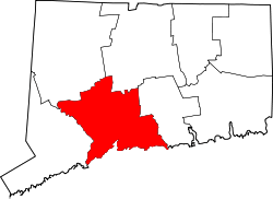
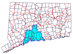
Greater New Haven is the metropolitan area whose extent includes those towns in the U.S. state of Connecticut that share an economic, social, political, and historical focus on the city of New Haven. It occupies the south-central portion of the state in a radius around New Haven.
The region is known for its educational and economic connections to Yale University, oceanside recreation and the beach-community feel of the shoreline towns east of New Haven, and the Trap Rock landscapes stretching north from New Haven.
The New Haven metropolitan statistical area (MSA) is the set of counties containing the contiguous urbanized area centered on the city of New Haven. The MSA consists of the entirety of New Haven County with 27 towns.[1] According to the U.S. Census Bureau, the New Haven MSA had a population of 861,113 in 2011.[2] The New Haven MSA is also included in the wider region known as the New York Tri-State Area.[3]
Definitions

There are several official definitions of Greater New Haven. There are twelve towns that are included in all definitions. These are:
- Bethany
- Branford
- East Haven
- Guilford
- Hamden
- Madison
- New Haven (central city)
- North Branford
- North Haven
- Orange
- Wallingford
- West Haven
New Haven Service Delivery Area
A service delivery area is a geographical area within which employment and training services are provided under the Job Training Partnership Act.[4] This definition contains 14 towns and additionally includes the towns of Clinton and Woodbridge.
South Central Region
The South Central Region is an officially designated region of Connecticut administered by a regional council of governments.[5] The regional council carries out land use, infrastructure, and long-term economic planning for the member towns. This definition contains 15 towns and includes the towns/cities of Meriden, Milford, and Woodbridge.
New Haven Labor Market Area
A labor market area, as defined by the U.S. Bureau of Labor Statistics, is an economically integrated area within which individuals can reside and find employment within a reasonable distance or can readily change employment without changing their place of residence.[6] This definition contains 17 towns including the towns of Cheshire, Clinton, Killingworth, Meriden, and Woodbridge.
New England City and Town Area
The New Haven NECTA is the set of towns containing the contiguous urbanized area centered on the city of New Haven, plus additional outlying towns that have a sufficient number of people commuting into the central towns. This definition includes 23 towns, adding the following ten towns:[7] Chester, Cheshire, Clinton, Deep River, Durham, Essex, Killingworth, Meriden, Middlefield, Old Saybrook, and Westbrook. This definition includes a significant portion of the Lower Connecticut River Valley, which is not usually included in local definitions of Greater New Haven. As of the 2000 Census, the NECTA had a population of 571,310.[8]
Metropolitan Statistical Area
The New Haven MSA is the set of counties containing the contiguous urbanized area centered on the city of New Haven. The MSA consists of the entirety of New Haven County with 27 towns.[9] This definition, while consistent with national definitions of metropolitan areas, includes the city of Waterbury and its southern and eastern suburbs, which are not usually included in local definitions of Greater New Haven. According to the U.S. Census Bureau, the New Haven MSA had a population of 846,766 as of 2005.[10] The New Haven MSA is also included in the New York-Newark-Bridgeport Combined Statistical Area.[11]
Transportation
Rail
New Haven Union Station serves as the central point of rail service in Greater New Haven.
Metro North's New Haven Line serves New Haven State St and New Haven Union Station in downtown New Haven, as well as Milford.
Shore Line East serves both New Haven stations plus Branford, Guilford, Madison, and Clinton in the region, with service to Old Saybrook and New London as well as limited service to west of New Haven.
Both of Amtrak's Northeast Corridor services go through New Haven Union Station; most Acela Express and all Northeast Regional trains stop. Additionally, Amtrak's New Haven-Springfield Shuttle offers local service to Springfield, which is planned to be supplemented by the Hartford Line commuter service.
Bus
CTTransit serves the Greater New Haven area.
References
- ↑ U.S. Census Bureau - Definitions of MSAs
- ↑ Annual Estimates of the Population of Metropolitan and Micropolitan Statistical Areas: April 1, 2000 to July 1, 2005
- ↑ U.S. Census Bureau - Definitions of Combined Statistical Areas
- ↑ Connecticut Department of Economic and Community Development - Service Delivery Areas
- ↑ Official website of the South Central Region
- ↑ Connecticut Department of Economic and Community Development - Labor Market Areas
- ↑ U.S. Census Bureau - Definitions of NECTAs
- ↑ Population in New England City and Town Areas (NECTAs) and Their Geographic Components in Alphabetical Order and Numerical and Percent Change: 1990 and 2000
- ↑ U.S. Census Bureau - Definitions of MSAs
- ↑ Annual Estimates of the Population of Metropolitan and Micropolitan Statistical Areas: April 1, 2000 to July 1, 2005
- ↑ U.S. Census Bureau - Definitions of Combined Statistical Areas
