Naval Air Station Patuxent River
| Naval Air Station Patuxent River Trapnell Field | |||||||||||||||||||
|---|---|---|---|---|---|---|---|---|---|---|---|---|---|---|---|---|---|---|---|
 | |||||||||||||||||||
| IATA: NHK – ICAO: KNHK - FAA: NHK | |||||||||||||||||||
| Summary | |||||||||||||||||||
| Airport type | Naval air station | ||||||||||||||||||
| Operator | United States Navy | ||||||||||||||||||
| Location | Patuxent River, Maryland | ||||||||||||||||||
| Built | 1 April 1943 | ||||||||||||||||||
| In use | Active | ||||||||||||||||||
| Elevation AMSL | 39 ft / 12 m | ||||||||||||||||||
| Coordinates | 38°17′10″N 76°24′42″W / 38.28611°N 76.41167°W | ||||||||||||||||||
| Runways | |||||||||||||||||||
| |||||||||||||||||||

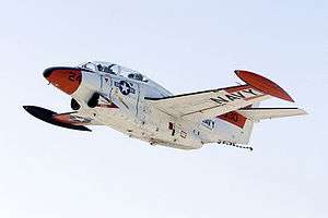
Naval Air Station Patuxent River (IATA: NHK, ICAO: KNHK, FAA LID: NHK), also known as NAS Pax River, is a United States naval air station located in St. Mary's County, Maryland, on the Chesapeake Bay near the mouth of the Patuxent River.
It is home to Headquarters, Naval Air Systems Command (NAVAIR), the U.S. Naval Test Pilot School, the Atlantic Test Range, and serves as a center for test and evaluation and systems acquisition relating to naval aviation.
Commissioned on April 1, 1943, on land largely acquired through eminent domain, the air station grew rapidly in response to World War II and continued to evolve through the Cold War to the present.
History
Genesis: 1937
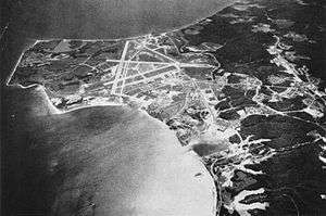
Situated on a peninsula between the Potomac River and the Chesapeake Bay at the mouth of the Patuxent River, NAS Patuxent River is located on 6,400 acres (26 km2) of what was once prime farmland, consisting of several large plantations, Mattapony, Susquehanna, and Cedar Point, as well as numerous tenant and sharecropper properties and a few clusters of vacation homes. The Cedar Point community included several churches, a post office, and a gas station. Some of the old homes now serve as quarters for Navy personnel stationed there.[1]
In 1937, the Navy's Bureau of Aeronautics sought to consolidate aviation test programs, previously being conducted at several stations, including Dahlgren and Norfolk, the Washington Navy Yard, Naval Air Station Anacostia in Washington, D.C., and the Naval Aircraft Factory in Philadelphia, Pennsylvania. Cedar Point was selected due to its remote location on the coastline, well removed from air traffic congestion, with ample space for weapons testing.[1]
1941: Wartime urgency
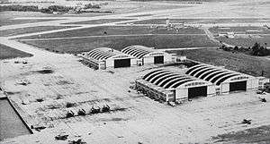
Fast Track Chartering of Base and Start of Construction
The onset of American involvement in World War II spurred establishment of the new air station.
Rear Admiral John Henry Towers, Chief of Bureau of Aeronautics, requested approval and authorization to begin construction on December 22, 1941. Secretary of the Navy, Frank Knox, gave approval on January 7, 1942 and construction began on April 4, 1942.
Hardships for Original Civilian Residents
The original civilian residents had about a month, until March 1, 1942, to relocate as the federal government purchased all the land at a cost of $712,287 for 6,412 acres (26 km2),[1] which in 2013 dollars would be the equivalent of being paid $1,261 per acre. Many residents were forced to sell land that had been in their families for generations. Some families had roots in the area going back 300 years. These included traditional farming, crabbing and fishing families and there were protests. National wartime urgency was however felt in Washington at the time to take precedence, and the process of eminent domain went through.
Rehabilitation of rail line
A lack of transportation in Saint Mary's County led the Navy to acquire and revitalize a branchline called the
Washington, Brandywine and Point Lookout Railroad (aka "The Farmers' Railroad") from Brandywine to Mechanicsville, Maryland, in June 1942 and build an extension south from Mechanicsville to the air station. Known as the U.S. Government Railroad, the rail line was steam-powered and operated south of Brandywine for exclusive official use until 1954, when the Pennsylvania Railroad assumed operation of the line. Rail service ended in 1965, and the line was subsequently scrapped, although the right-of-way is still very visible.
Extension of highway
A highway extension to the new air station was required by the project—250,000 tons of material were transported by either truck or water routes during a year of construction.[1]
Construction boom town
Employing some 7,000 at its peak of construction, the area had a Gold Rush "boom town" feel as local residents were joined by workers from all over the country, eager to get on the high-paying jobs on station.[1]
1942: Marines take over Security for a Short Time
On 20 October 1942, U.S. Marines first arrived and took over security. Today, the station utilizes Navy Masters-At-Arms (MA) and Department of Defense Police for standard local law enforcement, the Naval Criminal Investigative Service (NCIS) for high-profile criminal investigations, and a contract security force for access control.
During construction, housing needs far outstripped supply, and barracks were built for workers on the station. Later, several housing areas were erected off station for workers and their families in Lexington Park, formerly Jarboesville, named in honor of the USS Lexington, the Navy's second aircraft carrier, lost during the Battle of the Coral Sea on May 8, 1942.[1] The town's expansion had begun.
1943: Dedication

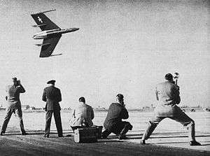
The station was formally commissioned "U.S. Naval Air Station, Patuxent River, Maryland" on 1 April 1943. In a ceremony presided over by RADM John S. McCain, Sr., then chief of the Bureau of Aeronautics, Patuxent River was referred to as "the most needed station in the Navy."[2] The unofficial name had been Cedar Point or the Naval Air Station at Cedar Point, but officials were concerned about possible confusion with the Marine Corps Air Station Cherry Point, North Carolina, so the new facility was named for the adjacent river.[1]
1950s: Test Pilot School and Facilities Launched
The base became a center for testing as several facilities were constructed throughout the 1950s and 1960s; including the U.S. Naval Test Pilot School (1958), the Weapons Systems Test Division (1960), and the Propulsion System Evaluation Facility. The base also served as the testing facility for the V-22 Osprey.
In addition to its role in testing naval aircraft, during the 1950s to 1970s Patuxent River served as an operational base for a Transport Squadron - VR-1, a TACAMO squadron - VQ-4, Airborne Training Unit Atlantic - AEWTULANT, and VW-11, VW-13 AN VW-15 and a number of Patrol Squadrons including VP-8, VP-44, VP-49, VP-24, VP-30 and VP-68.
1965: Addition of Reconnaissance Squadrons
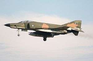
By 1965, reconnaissance Squadron VQ-4, based at NAS Patuxent River, began using Lockheed C-130s equipped with special communications equipment to perform their around-the-clock Take Charge and Move Out (TACAMO) mission. VQ-4 provided long-range, very-low-frequency communications relay between the National Command Center and the ballistic missile submarine fleet. Two A-7A Corsair II aircraft made the transatlantic crossing from NAS Patuxent River to Évreux, France, in 1967, racking up 3,327 nautical miles in just over seven hours, an unofficial long distance, non-refueled flight by light attack jet aircraft.
Cooperation with the British also led to transatlantic visits to PAX River by RAF squadrons.
1970s: Ongoing Development of Major Naval Aircraft
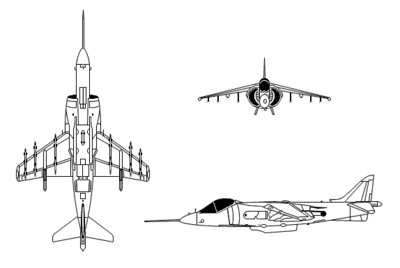

Research and development at NAS Patuxent River forged ahead in the 1970s. The Grumman F-14 Tomcat, the McDonnell Douglas AV-8B Harrier II jump jet, and the Lockheed P-3 Orion were just a few of the major aircraft programs undergoing the rigorous test and evaluation process at NAS Patuxent River. Helicopter programs also achieved major milestones during the 1970s. The Naval Air Test Center (NATC) at NAS Patuxent River took part in helicopter development and testing for new roles, such as minesweeping. The final flight of the service acceptance trials for the Bell AH-1 SuperCobra gunship were made at NATC Patuxent River.
1976: Renaming of airfield
On 1 April 1976, Patuxent River's air field was named after pioneering aviator VADM Frederick M. Trapnell, a former commander of the Naval Air Test Center at the station. Keynote address speaker, ADM Frederick H. Michaelis, Chief of Naval Material, noted: "All who fly in Navy blue remain indebted to Vice Admiral Trapnell. This field will serve as a living reminder of that debt."[3]
1990s: End of Cold War, base consolidations favor PAX River NAS
Growth
Since the end of the Cold War, the Pentagon's Base Realignment and Closure measures have migrated research and testing facilities for both rotary and fixed-wing aircraft to NAS Patuxent River from decommissioned bases. The complex now hosts over 17,000 people, including active-duty service members, civil-service employees, defense contractor employees, and military dependents.
Film Location
The base was also used as a filming location for the Harrison Ford film Random Hearts (1999). Ford and director Sydney Pollack both visited Naval Air Station Patuxent River. Ford, a certified pilot, flew the aircraft himself.
Present
Additional commands at NAS Patuxent River include Air Test Wing Atlantic and the Naval Air Warfare Center Aircraft Division (NAWCAD). On 18 September 2014, Captain Heidi Flemming became the first female commanding officer of NAS Patuxent River.[4]
Tenant Commands
_are_shown_the_Aircraft_Prototype_Facility_at_Nav.jpg)
- Naval Air Systems Command
- U.S. Naval Test Pilot School
- Air Test and Evaluation Squadron 1
- Scientific Development Squadron 1
- Air Test and Evaluation Squadron 20
- Rotary Wing Test Squadron 21
- Air Test and Evaluation Squadron 23
.
Patuxent River Naval Air Museum


The Patuxent River Naval Air Museum adjoins the base and can be accessed by the general public without coming onto the main base.
- Patuxent River Naval Air Museum official website
_demonstrator_completes_its_first_shore-based_arrested_landing_at_Naval_Air_Staion%2C_Patuxent_River%2C_Md.%2C_May_4%2C_2013_130504-N-ZZ999-101.jpg)

- See: U.S. Navy Museum and Other Navy Museums
See also
Area Information
Town
The base is located in Lexington Park, Maryland
Local off base government and services
The town is unincorporated and is under the Saint Mary's County government which also provides all municipal services.
Area Civilian transportation
Limited local buses are provided through St. Mary's Transit , and commuter bus service to Washington, D.C. is provided by MTA .
The nearest commercial airports are Reagan National Airport in Washington D.C. and Baltimore Washington International Airport (BWI) in suburban Baltimore.
St. Mary's County is also served by a civilian general aviation airport called Captain Walter Duke Regional Airport near Leonardtown, Maryland
Higher Education
- Nearby St. Marys College of Maryland is ranked 4th in the nation under the category "Best Colleges for Veterans" [5] by U.S. News & World Report college rankings.[6]
- It is also ranked 5th in the nation under the category "Public Colleges".[7] It's admissions standards are however, rigorous.[7]
- St. Marys College also has extensive "open to the public" evening and weekend educational enrichment programs, including public lectures, seminars, films and special events. It also hosts a summer writing workshop
- College of Southern Maryland is a regional community college, it has a training center near the base in Lexington Park and a main campus 15 miles away in Leonardtown, Maryland
- Southern Maryland Higher Education Center in California, Maryland.
- Paul Hall Center for Maritime Training and Education is a Merchant Marine school in nearby Piney Point, Maryland.
Local Recreation and Tourism
- Point Lookout State Park nationally recognized natural area and historic site; former Civil War prison camp, beaches, fishing, camping
- St. Mary's City site of first settlement in the Maryland colony, four museums and reconstructed colonial town and living history center (7 miles from base)
- Patuxent River Naval Air Museum Naval aviation history, including history of test pilots and naval aviation development at PAX River NAS, many aircraft on display
- Solomons Island Naval recreation facility in nearby Solomons Island Maryland (reachable by bridge)
- Sotterley Plantation reconstructed plantation, pre-Civil War history museum
- USS Tulip monument and federal grave site for Civil War sailors who died in the explosion of a Union gunship in area waters in 1864
- Point Lookout Light House
- Piney Point Lighthouse and Museum
- Cecils Old Mill museum, art gallery and artists coop in nearby Great Mills, Maryland
- National Register of Historic Places listings in St. Mary's County, Maryland many buildings date back to the 1600 and 1700s
- Leonardtown county seat, historic town dating back to the 1600s
- Tudor Hall, St. Marys County Historical Society (limited hours)
Sources
References
- 1 2 3 4 5 6 7 Naval Air Systems Command Headquarters, Strategic Planning Division, "The History of Naval Air Station Patuxent River, Maryland," undated, but circa 2000.
- ↑ "Patuxent River". Retrieved 2009-05-02.
- ↑ "In the center of change: Frederick M. Trapnell". Retrieved 2009-05-02.
- ↑ http://www.thebaynet.com/articles/0914/pax-river-command-changes-to-first-woman-co.html
- ↑ "National Liberal Arts
- Colleges Summary: St. Mary's College of Maryland" U.S. News & World Report Best Colleges and Universities Ranking, 2014 http://colleges.usnews.rankingsandreviews.com/best-colleges/rankings/national-liberal-arts-colleges/veterans
- ↑ "National Liberal Arts Colleges Summary: St. Mary's College of Maryland" U.S. News & World Report Best Colleges and Universities Ranking, 2014 http://colleges.usnews.rankingsandreviews.com/best-colleges/rankings/national-liberal-arts-colleges/veterans
- 1 2 "National Liberal Arts Colleges Summary: St. Mary's College of Maryland" U.S. News & World Report Best Colleges and Universities Ranking, 2014 http://colleges.usnews.rankingsandreviews.com/best-colleges/st-mary-s-college-of-maryland-163912/overall-rankings
External links
| Wikimedia Commons has media related to Naval Air Station Patuxent River. |
Military
- Naval Air Systems Command (NAVAIR)
- Naval Air Warfare Center Aircraft Division
- NAS Patuxent River, Globalsecurity.org
- FAA Airport Diagram (PDF), effective November 10, 2016
- Resources for this U.S. military airport:
- FAA airport information for NHK
- AirNav airport information for KNHK
- ASN accident history for NHK
- NOAA/NWS latest weather observations
- SkyVector aeronautical chart for KNHK
Area Recreation and attractions
- St. Mary's County Travel and Tourism
- Historic St. Marys City Site of first settlement of Maryland Colony, museums and reconstructed colonial town
- Solomons Island Naval recreation facility in nearby Solomons Island Maryland (reachable by bridge)
- United States Colored Troops Memorial Statue memorial to 700 African-American soldiers and sailors from St. Mary's County, Maryland who served in the Union forces during the American Civil War. Includes an educational display. Recreational community park setting. Special celebrations as well.
.svg.png)