Nahr Ibrahim (municipality)
This article is about the village in Lebanon. For the river in Lebanon, see Abraham River.
| Nahr Ibrahim نهر ابراهيم | |
|---|---|
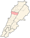
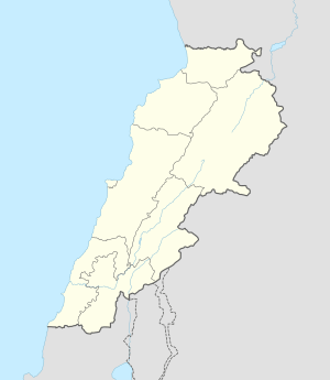 Nahr Ibrahim Location in Lebanon | |
| Coordinates: 34°3′58″N 35°38′42″E / 34.06611°N 35.64500°ECoordinates: 34°3′58″N 35°38′42″E / 34.06611°N 35.64500°E | |
| Country | Lebanon |
| Governorate | Mount Lebanon |
| District | Jbeil |
| Area | |
| • Total | 341 ha (843 acres) |
| Elevation | 220 m (720 ft) |
Nahr Ibrahim (Arabic: نهر ابراهيم) is a municipality in the Jbeil District of Mount Lebanon Governorate, Lebanon. It is 47 kilometers north of Beirut. Nahr Ibrahim has an average elevation of 220 meters above sea level and a total land area of 341 hectares. The village has one public school, which enrolled 44 students in 2008. There were four companies with more than five employees operating in the village as of 2008.[1] Its inhabitants are predominantly Maronite Catholics.[2]
References
- ↑ "Nahr Ibrahim". Localiban. Localiban. 2008-01-16. Retrieved 2016-02-12.
- ↑ "Elections municipales et ikhtiariah au Mont-Liban" (pdf). Localiban. Localiban. 2010. p. 19. Retrieved 2016-02-12.
Capital: Jbeil | ||
| Towns and villages |
|  |
| Landmarks |
| |
This article is issued from Wikipedia - version of the 2/12/2016. The text is available under the Creative Commons Attribution/Share Alike but additional terms may apply for the media files.