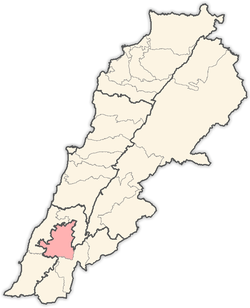
Nabatieh
| Nabatieh النبطية | |
|---|---|
| City | |
|
Nabatieh, 2006 | |
 Nabatieh Location within Lebanon | |
| Coordinates: 33°21′50″N 35°29′15″E / 33.36389°N 35.48750°ECoordinates: 33°21′50″N 35°29′15″E / 33.36389°N 35.48750°E | |
| Grid position | 125/160 L |
| Country |
|
| Governorate | Nabatieh Governorate |
| District | Nabatieh District |
| Area | |
| • City | 8 km2 (3 sq mi) |
| • Metro | 21 km2 (8 sq mi) |
| Elevation | 418 m (1,371 ft) |
| Population | |
| • City | 40,000 |
| • Metro | 85,000 |
| Time zone | EET (UTC+2) |
| • Summer (DST) | EEST (UTC+3) |
| Dialing code | +961 |


Nabatieh (Arabic: النبطية, Nabaṭīya), or Nabatîyé, is the principal town of the Nabatieh Governorate, in southern Lebanon. The population is not accurately known as no census has been taken in Lebanon since the 1930s; estimates range from 15,000 to 120,000. A 2006 population estimate by the now-closed German population site called World Gazetteer put the population at 100,541, which would make it the fifth largest city in Lebanon, after Tyre, Sidon, Tripoli, and Beirut according to those 2006 population estimates of Lebanese cities,[1] but after an update in either 2007 or 2008 and calculations for the following years the 2013 population estimate turned out to be much lower at 36,593 and making the city the 11th largest in Lebanon behind Tyre, Bint Jbeil, Alayh, Kafr 'Aşş, Zahlé, Sidon, Baalbek, Jounieh, Tripoli and Beirut according those 2013 estimates.[2] It is the main city in the Jabal Amel area and the chief center for both the mohafazat, or governorate, and the kaza, or canton both also called Nabatieh. Nabatieh is an important town both economically and culturally.
A market is held every Monday where traders and visitors from neighboring villages gather in the center of the town to exchange their goods in an area known in Arabic as the Souq Al Tanen. There are also branches of several banks, hospitals, restaurants and cultural centers of interest to tourists. Every year, the city commemorates the Battle of Karbala to remember the martyrdom of Imam al Husayn.
Nabatieh was the birthplace of several learned men, including linguist and Arab nationalist leader Ahmad Rida, historian Muhammad Jaber Al Safa, scientist Hassan Kamel Al-Sabbah (nephew of Ahmad Rida) and theologian Sheikh Ahmed Aref El-Zein.
History
In the 1596 tax records, it was named as Nabatiyya al-Tahta, located in the Ottoman nahiya (subdistrict) of Sagif under the liwa' (district) of Safad, with a population of 151 households and 28 bachelors, all Muslim. The villagers paid taxes on goats and beehives, "occasional revenues", a press for olive oil or grape syrup, a market toll, and a fixed sum; a total of 9,030 akçe.[3][4]
In 1875, Victor Guérin found Nabatieh et-Thata ("The lower Nabatieh") to have 1,500 Metuali inhabitants, in addition to 300 Christians; mostly Greek Orthodox, but also some Maronites.[5]
Historic structures
Beaufort Castle
On the top of a hill overlooking the southern Beqaa Valley towards Damascus stands Belfort or Beaufort castle, known to Arab travellers as Shqif Arnun, the word shqif being a Syriac term meaning high rock. The castle, although looking inaccessible, can be reached with little difficulty from the village of Arnoun, which lies 7 km southeast of Nabatieh. There is no conclusive evidence for the age of this castle or for who built it.
The Crusaders repaired and fortified Beaufort Castle during the twelfth century and it became the most important fortress in Lebanon.
Mosques
Nabatieh has two historic mosques. One was built in the 16th century and lies in the center of the town. Another, known as "the Mosque of the Prophet," dates to the Mamluk period and is located in Nabatieh al Fawqa.
Education
Mission laïque française Lycée Franco-Libanais Habbouche-Nabatieh is located few km to the north of the city. The National Evangelical School (Known Previously as American School for Girls in Nabatieh) The Christian College Notre Dame des Soeurs Antonines is one of the oldest institutions in the city.[6]
Demographics
The inhabitants of Nabatieh are predominantly Shi'a Muslims, with a significant minority of Greek Catholics. The Nabatieh district has three representatives in the Lebanese government, all belonging to the Shi'a religion, in accordance with Lebanon's sectarian congressional system.
References
Bibliography
- Hütteroth, Wolf-Dieter; Abdulfattah, Kamal (1977). Historical Geography of Palestine, Transjordan and Southern Syria in the Late 16th Century. Erlanger Geographische Arbeiten, Sonderband 5. Erlangen, Germany: Vorstand der Fränkischen Geographischen Gesellschaft. ISBN 3-920405-41-2.
- Guérin, Victor (1880). Description Géographique Historique et Archéologique de la Palestine (in French). 3: Galilee, pt. 2. Paris: L'Imprimerie Nationale.
- Rhode, Harold (1979). Administration and Population of the Sancak of Safed in the Sixteenth Century. Columbia University.

