Mount Pulai
| Mount Pulai | |
|---|---|
| Gunung Pulai | |
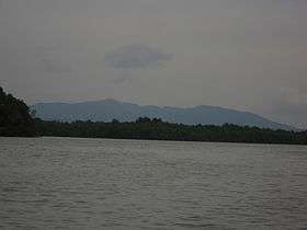 Mount Pulai from the Pulai River | |
| Highest point | |
| Elevation | 654 m (2,146 ft) |
| Coordinates | 01°36′10″N 103°32′45″E / 1.60278°N 103.54583°E |
| Geography | |
| Location | Kulai, Johor, Malaysia |
| Parent range | Titiwangsa (foothill) |
Mount Pulai (Malay: Gunung Pulai) is a mountain in Kulai District, Johor, Malaysia.[1]
History
On 6 September 2016, the Mount Pulai Recreational Forest 1 was reopened after it was closed for 15 years since 2001 due to mud flood which caused five casualties.[2]
Geology
The mountain features the Pulai Waterfall and Mount Pulai Recreational Forest 1 and 2.
Infrastructure
The mountain houses three telecommunication towers. Two are located at the peak of the mountain and another one is located slightly lower from the peak.[3]
See also
References
| Wikimedia Commons has media related to Mount Pulai. |
Coordinates: 1°36′N 103°33′E / 1.600°N 103.550°E
This article is issued from Wikipedia - version of the 11/21/2016. The text is available under the Creative Commons Attribution/Share Alike but additional terms may apply for the media files.