Mount Gahinga
| Mount Gahinga | |
|---|---|
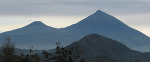
 Mts. Gahinga (left) and Muhabura (right) | |
| Highest point | |
| Elevation | 3,474 m (11,398 ft) |
| Prominence | 2,821 m (9,255 ft) |
| Coordinates | 1°23′14″S 29°38′37″E / 1.3873°S 29.6435°ECoordinates: 1°23′14″S 29°38′37″E / 1.3873°S 29.6435°E |
| Naming | |
| Translation | A little pile of stones (Kinyarwanda) |
| Geography | |
| Location | Rwanda–Uganda |
| Parent range | Virunga Mountains |
| Geology | |
| Mountain type | Stratovolcano |
| Last eruption | unknown |
| Climbing | |
| Easiest route | Hike |
Mount Gahinga, is a dormant/extinct volcano in the Virunga Mountains on the border between Rwanda and Uganda. Gahinga lies between Muhabura and Sabyinyo, but is the smallest of these three. Mount Gahinga, also known in the local Kinyarwanda/Rufumbira dialect as "a small pile of stones", has a swampy caldera on its peak. The caldera is believed to be about 180 meters wide.[1] Mgahinga Gorilla National Park also got its name from this volcano. Mount Gahinga, whose elevation is 3,474 meters, is part of a chain of 8 volcanic mountains of the Mufumbiro ranges. The volcano chain spans across Uganda, Rwanda and the Democratic Republic of Congo.
The vegetation across the mountain can be described as afro-montane with bamboo composing the main vegetation. Like Muhabura and Sabyinyo, the bamboo forests on Mount Gahinga are a habitat of the endangered mountain gorillas. There are several other species of animals and birds that form part of the Mount Gahinga ecosystem. The golden monkeys are notable to these.