Moorooduc railway station
Moorooduc | |
|---|---|
| Mornington Railway Station | |
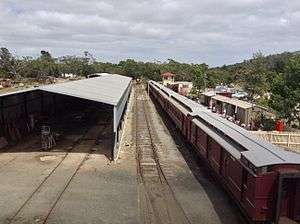
 The platform and rail yard as viewed from the platform | |
| Line(s) |
Mornington Railway former Mornington Line |
| Platforms | 1 with dock |
| Tracks | 7 (4 In use) |
| Other information | |
| Status | Staffed |
| History | |
| Opened | 1889 |
| Closed | 22 June 1981 |
Moorooduc railway station is located on Two Bays Road, Mount Eliza, Victoria, Australia. The station is home to the Mornington Railway Preservation Society. Adjacent to the station is the Mount Eliza Regional Park which incorporates the Moorooduc Quarry Flora and Fauna Reserve. Moorooduc station has one platform, which terminates services on the line. Only one track is currently used for services, with the other five are for train maintenance, storage, repairs and locomotives changing ends.
Facilities
Moorooduc station has a heritage signal box obtained from the now defunct Somerton Station (Now roxburgh park). Currently, it is not used and is open for free inspection by passengers[1]
A Toilet block is being installed currently.[2] A dock is present but is mainly used for renovations and maintenance. A footbridge from the now closed North Fitzroy Station is also at the station.[3]
Future Plans
The Mornington Railway have worked hard to restore the old train line that continues over the highway adjacent to it and into a pile of vegetation. The track runs all the way past Peninsula Link and into Baxter station A few kilometers down the line will be a possible proposed Sumner Road station, but the outcome of the project will vary, especially in terms of money. The railway line will continue and join onto the Stony Point railway line and then will terminate at Baxter.
Gallery
 The 'Mcdonalds car'
References
- ↑ "Signal Box". Mornington Railway Preservation Society. Retrieved 18 November 2013.
- ↑ Mornington Railway Preservation Society Current projects http://www.morningtonrailway.org.au/projects.htm Retrieved November 18, 2013
- ↑ "Footbridge-Mornington Railway Preservation Society". Mornington Railway Preservation Society.
External links
- Mornington Railway Preservation Society
- Photograph of Steam Engine K163 and Map
- The Heritage Signal Box
- The Footbridge
- Moorooduc railway station map page
| Station Navigation | ||||
|---|---|---|---|---|
| Mornington Railway | ||||
| Previous Station | Terminus | | | Tanti Park | Next Station |
| Entire line | ||||
Coordinates: 38°12′50.28″S 145°06′26.43″E / 38.2139667°S 145.1073417°E
| Closed station navigation | ||||
|---|---|---|---|---|
| Mornington line | ||||
| ← Previous station | Baxter | | | Tanti Park | Next station → |
| Closed stations | ||||