Montopoli in Val d'Arno
| Montopoli in Val d'Arno | ||
|---|---|---|
| Comune | ||
| Comune di Montopoli in Val d'Arno | ||
|
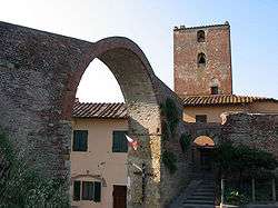
Arch and Tower of Castruccio Castracani. | ||
| ||
 Montopoli in Val d'Arno Location of Montopoli in Val d'Arno in Italy | ||
| Coordinates: 43°40′N 10°45′E / 43.667°N 10.750°E | ||
| Country | Italy | |
| Region | Tuscany | |
| Province / Metropolitan city | Pisa (PI) | |
| Frazioni | Capanne, Castel del Bosco, San Romano, Marti | |
| Government | ||
| • Mayor | Alessandra Vivaldi | |
| Area | ||
| • Total | 29.9 km2 (11.5 sq mi) | |
| Elevation | 98 m (322 ft) | |
| Population (2008[1]) | ||
| • Total | 11,012 | |
| • Density | 370/km2 (950/sq mi) | |
| Demonym(s) | Montopolesi | |
| Time zone | CET (UTC+1) | |
| • Summer (DST) | CEST (UTC+2) | |
| Postal code | 56020 | |
| Dialing code | 0571 | |
| Website | Official website | |

Montopoli in Val d'Arno is a comune (municipality) in the Province of Pisa in the Italian region Tuscany, located about 40 kilometres (25 mi) southwest of Florence and about 30 kilometres (19 mi) east of Pisa.
Montopoli in Val d'Arno borders the following municipalities: Castelfranco di Sotto, Palaia, Pontedera, San Miniato, Santa Maria a Monte.
It is home to a tower and an arch named after Castruccio Castracani, once belonging to a castle. Outside of town is the Franciscan Sanctuary of the Madonna di San Romano.
References
Twin towns
 Torella dei Lombardi, Italy
 Maussane-les-Alpilles, France
External links
| Wikimedia Commons has media related to Montopoli in Val d'Arno. |
This article is issued from Wikipedia - version of the 10/8/2016. The text is available under the Creative Commons Attribution/Share Alike but additional terms may apply for the media files.