Mohonk Preserve

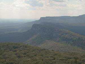
The Mohonk Preserve is New York State's largest visitor- and member-supported nature preserve, with 165,000 annual visitors and 8,000 acres (32 km2) of cliffs, forests, fields, ponds and streams. It is located on the Shawangunk Ridge, a section of the Appalachian Mountains, 90 miles (140 km) north of New York City in Ulster County, New York. The Preserve maintains over 70 miles (110 km) of carriage roads and 40 miles (60 km) of trails for hiking, cycling, trail running, cross-country skiing, snowshoeing, and horseback riding. It is also a major destination for rock climbers, hosting 50,000 climbers each year who enjoy more than 1,000 climbing routes.[1][2]
History
The origins of the preserve date to 1869, when twin brothers Albert and Alfred Smiley purchased Lake Mohonk and established the Mohonk Mountain House. On February 26, 1963, the Smiley family, friends, neighbors and supporters formed the Mohonk Trust to protect the area's unique natural landscape for future generations. The "property" of the Mohonk Trust on that day in 1963 consisted of $100, a gift from Mabel Craven Smiley. Land was acquired by the Mohonk Trust over the years, and it became the Mohonk Preserve Inc. in 1978. According to their 2012 IRS Form 990 their assets today exceed $20 million. Through the support of members, donors and partners, the preserve has become a center for outdoor education and a conservation advocate, especially for natural lands in the Shawangunks and the Hudson Valley. Its mission includes land protection and stewardship, sponsorship of environmental education programs, which according to Preserve officials have served more than 100,000 children over a thirty-year period, and maintenance of biological, weather, and natural history records spanning more than a century.[2]
In 1986, the Mohonk Preserve and Mohonk Mountain House together were designated a National Historic Landmark.[3]
The name "Moggonck" appeared in early boundary records referring to the "high hill", the crag now named Skytop where the Smiley Tower is located. The spelling change from "gg" to "h" was probably done for aesthetic reasons. The word Moggonck was possibly derived from the Lenape maxkwung, "place of bears", or from the Munsee maxkawenge, "hill of bears".[4]
Description
Headquarters of the not-for-profit Mohonk Preserve are in Gardiner, New York. Most of the land is in the town of Gardiner, but there is also land in the towns of Marbletown, Rosendale, New Paltz, and Rochester. Preserve lands extend for nearly 8 miles (13 km) from Rosendale to Millbrook Mountain.
More than 75% of the Preserve's funding comes from contributions, memberships and investments. Grants from land conservation organizations, including some from the New York State Conservation Partnership Program, and funds from the state's Environmental Protection Fund amount to 23% of income. It was the first land trust established on the northern Shawangunk Ridge.
The Preserve's mission is to protect the Shawangunk Mountains by inspiring people to care for, enjoy, and explore the natural world. To accomplish its mission, the Preserve conducts programs in four key areas - environmental education, serving both school children and adults; land protection, saving high-priority land on the ridge; land stewardship, balancing the protection of land and wildlife with opportunities for recreation; and scientific research, creating a "living laboratory" on the land. The land is home to more than 1,400 plant and animal species, including the peregrine falcon and 2,000 acres (810 ha) of rare dwarf pitch pine. Restricted deer hunting is allowed with the aim of preventing ecological damage due to overbrowsing.
There is a day fee of $12 for hiking and $17 for cycling and rock climbing. Annual memberships are available. Free one-month memberships were offered to Ulster County residents in the spring and again in the fall of 2014.[5] Hours of operation are from sunrise to one hour past sunset.[2]
Minnewaska State Park Preserve adjoins the Mohonk Preserve lands to the south, and protects another 12,000 acres (49 km2) of former property of another member of the Smiley family as a state park.
References
- ↑ "Who We Are". Mohonk Preserve. Retrieved September 16, 2016.
- 1 2 3 Reed, Gretchen (July 16, 2014). "Mohonk Preserve Legacy Endures". Poughkeepsie Journal. Retrieved September 16, 2016.
- ↑ "Timeline". Mohonk Preserve. Retrieved September 16, 2016.
- ↑ Fried, Marc B. (2005). Shawangunk Place-names: Indian, Dutch and English Geographical Names of the Shawangunk Mountain. New Paltz, NY: Barber Books.
- ↑ "Healthy Ulster: Autumn at Mohonk Preserve". Town of Marbletown official website. Archived from the original on 8 December 2014. Retrieved 6 December 2014.
External links
Coordinates: 41°44′50″N 74°12′35″W / 41.74722°N 74.20972°W