M'lang, Cotabato
| M'lang | ||
|---|---|---|
| Municipality | ||
| ||
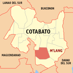
 Map of Cotabato with M'lang highlighted | ||
.svg.png) M'lang Location within the Philippines | ||
| Coordinates: 06°57′N 124°53′E / 6.950°N 124.883°ECoordinates: 06°57′N 124°53′E / 6.950°N 124.883°E | ||
| Country | Philippines | |
| Region | SOCCSKSARGEN (Region XII) | |
| Province | Cotabato | |
| Congr. district | 3rd District of Cotabato | |
| Incorporated | August 3, 1951 | |
| Barangays | 37 | |
| Government[1] | ||
| • Mayor | Russel Abonado | |
| Area[2] | ||
| • Total | 312.13 km2 (120.51 sq mi) | |
| Population (2010)[3] | ||
| • Total | 87,749 | |
| • Density | 280/km2 (730/sq mi) | |
| Demonym(s) | Mlangeños | |
| Time zone | PST (UTC+8) | |
| ZIP code | 9402 | |
| Dialing code | +63 (0)64 | |
| Website |
www | |
"M'lang" (Hiligaynon: "Banwa sang M'lang"; Filipino: "Bayan ng M'lang") is a first class Municipality in the Province of Cotabato, Philippines.
Barangays
M'lang is politically subdivided into 37 Barangays.[2]
- Bagontapay
- Bialong
- Buayan
- Calunasan
- Dalipe
- Dugong
- Dungo-an
- Gaunan
- Inas
- Katipunan
- La Fortuna
- La Suerte
- Langkong
- Lepaga
- Liboo
- Lika
- Luz Village
- Magallon
- Malayan
- New Antique
- New Barbaza
- New Kalibo
- New Consolacion
- New Esperanza
- New Janiuay
- New Lawa-an
- New Rizal
- Nueva Vida
- Pag-asa
- Poblacion A
- Poblacion B
- Pulang-lupa
- Sangat
- Tawantawan
- Tibao
- Ugpay
- Palma-Perez
History
The Name M'lang was derived from a Maguindanaoan word "TAMLANG" which means BAMBOO.
In 1930's Migrants From Visayas (Panay) and some parts of Luzon settled in M'lang. Jacinto Paclibar, who was in search for more fertile lands and vast settlement was the first Christian who settled in M'lang. He became the District Mayor of Kidapawan and Deputy Governor of the Empire Province of Cotabato under Datu Udtog Matalam.He had in mind a government assisted subdivision project so that landless settlers may have their share to utilize fertile lands for farming and settlement.
M'lang became regular Municipality on August 3, 1951, by virtue of Executive Order No. 462 of the President of the Philippines by the then President Elpidio Quirino, with territories taken from the adjacent towns of Kidapawan (its mother municipality) and Buluan of the now Maguindanao Province.
Education
- Notre Dame of M'lang
- Mlang Pilot Elementary School
- Mlang National High School
- Southern Baptist College
- Mariano Untal Memorial High School
- Bagontapay Central Elementary School
Transportation
- Airport
Located in Barangay Tawan-Tawan M'lang, Cotabato with 1.2 kilometer runway with a capability for Commercial flights. The airport is primarily intended to support the transport of agricultural produce from central part of Mindanao
References
- ↑ "Official City/Municipal 2013 Election Results". Intramuros, Manila, Philippines: Commission on Elections (COMELEC). 12 May 2014. Retrieved 3 June 2014.
- 1 2 "Province: COTABATO (NORTH COTABATO)". PSGC Interactive. Makati City, Philippines: National Statistical Coordination Board. Retrieved 3 June 2014.
- ↑ "Total Population by Province, City, Municipality and Barangay: as of May 1, 2010" (PDF). 2010 Census of Population and Housing. National Statistics Office. Retrieved 3 June 2014.
External links
 |
Kabacan | Matalam | Kidapawan |  |
| Pagalungan, Maguindanao | |
Makilala | ||
| ||||
| | ||||
| Tulunan |
