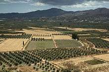
Messara Plain

The Messara Plain or simply Messara (Greek: Μεσσαρά) is an illuvial plain in southern Crete, stretching about 50 km west-to-east and 7 km north-to-south, making it the largest plain in Crete.
On a hill at its west end are the ruins of Phaestus,[1] near the middle are the ruins of the ancient city of Gortys.
Since 1500 BC the plain has grown up to 6 km due to a buildup of illuvial sediment. Clays from Messara have been found to be the source of significant amounts of Minoan pottery; soil and rock types from the fringes of Messara, particularly the foothills of the Asterousia Mountains at the south and the foothills to the north within the Psiloritis Mountains.[2]
In the Messara, olive trees, vineyards and horticultural crops are grown here. Part of the products grown here are placed on the domestic market. Α substantial part of the produced olive oil is then exported to European markets. The Messara Plain is also home to the indigenous Messara horse.[3][4][5]
References
| Wikimedia Commons has media related to Messara. |
- ↑ "Phaistos". themodernantiquarian.com.
- ↑ Joseph W. Shaw, A Lm Ia Ceramic Kiln in South-Central Crete: Function and Pottery Production, 2001, ASCSA, 172 pages ISBN 0-87661-530-2
- ↑ Hendricks, Bonnie. International Encyclopedia of Horse Breeds. University of Oklahoma Press, 1996, p. 283. ISBN 0-8061-2753-8.
- ↑ Jasper Nissen: Enzyklopädie der Pferderassen. Franckh-Kosmos Verlags GmbH & Co, Stuttgart 2003, ISBN 3-440-09723-4 (German)
- ↑ http://efabis.tzv.fal.de/cgi-bin/EfabisWeb.cgi?sid=-1,reportsreport8a_50008410
Coordinates: 35°02′14″N 24°50′46″E / 35.03722°N 24.84611°E