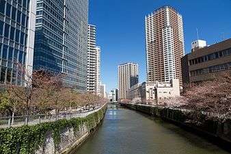
Meguro River
| Meguro River | |
|---|---|
.jpg) Meguro River near Naka Meguro | |
| Country | Japan |
| Basin | |
| Main source | Confluence of the Kitazawa and Karasuyama tributaries, Tokyo, Japan |
| River mouth | Shinagawa, Tokyo, Tokyo Bay |
| Basin size | 45.8 km2 (17.7 sq mi) |
| Physical characteristics | |
| Length | 7.82 km (4.86 mi) |
The Meguro River (目黒川 Meguro-gawa) is a river which flows through Tokyo, Japan. Its tributaries include the Kitazawa River and the Karasuyama River. The river flows into Tokyo Bay near the Tennōzu Isle Station.
The river is 7.82 km (4.86 mi) in length and passes through Setagaya, Meguro and Shinagawa wards.
The river banks are extensively landscaped and act as an urban green space for communities along its length. Close to the source of the river in Setagaya, the river is divided vertically between a large underground storm drain and surface level landscaped ornamental stream. At Ōhashi Junction where the river passes under the Route 246 and the Tōmei Expressway, the river re-emerges as a broader, surface level water channel.
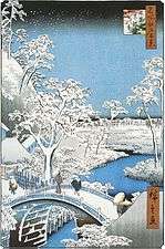
The river is a popular venue for cherry blossom viewing in the spring.[1][2]
Gallery
|
.jpg)

.jpg)
See also
References
- ↑ "Meguro Net Hanami Guide". Retrieved 19 March 2014.
- ↑ "Best Cherry Blossom Viewing Locations". Japan-guide.com. Retrieved 2 April 2014.
Coordinates: 35°38′45″N 139°41′55″E / 35.645927°N 139.698611°E