McGowan's Pass
Coordinates: 40°47′36″N 73°57′18″W / 40.79333°N 73.95500°W

McGowan's Pass (sometimes spelled "McGown's") is a topographical feature of Central Park in New York City, just west of Fifth Avenue and north of 102nd Street. It has been incorporated into the park's East Drive since the early 1860s.[2] A steep hill descending into a switchback road, it is a popular training route for competitive bicyclists and runners.
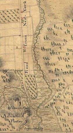
Although the name is usually omitted from maps today, McGowan's Pass was clearly marked on charts of the region from the Revolutionary War until the early 20th Century. It acquired its name from the McGowan or McGown family who kept a tavern (initially named "The Black Horse," but popularly called "McGowan's") near there from 1756 through the Revolutionary period, and owned the surrounding property until the 1840s.[3]
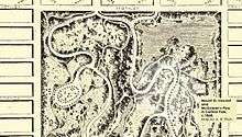
The area was incorporated into Central Park after 1860, when the Park's boundaries were extended north from the line of 106th Street to 110th Street, and the Harlem Meer was built in the Park's northeast corner. At this time a new section of East Drive was made to veer sharply to the west and south and again to the north, bypassing the Meer.[4]
Colonial era

In Dutch Colonial days, this area of north Manhattan was part of the "commons," land administered by the community of Nieuw Haarlem as a whole. During the 1660s-1690s, as Manhattan passed back and forth between the Dutch and English, the colony of New Harlem lost its autonomy. Common Lands were sold off in 1712. Much of this property in upper Manhattan passed to members of the extensive Benson and Dyckman families, who would continue to own much of northern Manhattan well through the 1800s.[5]
In the 1740s Jacob Dyckman, Jr. purchased the lands along the Pass from his Uncle George. He planted orchards and built a house and outbuildings, including a public house, "At the Sign of the Black Horse." During a yellow fever epidemic in 1752, the Colonial Assembly decamped from downtown New York and met in the Black Horse tavern, while boarding a half-mile east at the farm of Dyckman's cousin, Benjamin Benson.[5]
In 1756 Dyckman decided to move back north near his family in Spuyten Duyvil, and build a new tavern by the Harlem River. He advertised his Harlem property for sale[6] and sold it a few days later to his in-laws, Daniel McGown (as he spelled himself) and Catherine Benson McGown. With their son Andrew, the McGowns would run the Black Horse tavern until after the Revolutionary War.
Revolutionary War to Civil War
From 1776 until 1783, during the British occupation of New York, McGowan's Pass was a key high-ground position on the route between New York City to the south and Fort Knyphausen (Fort Washington) to the north. For most of this period, the area around the Pass was the site of a Hessian encampment.[7] After the Treaty of Paris, British and Hessians marched through the Pass when evacuating north Manhattan; and George Washington likewise came through the Pass when he reentered New York on Evacuation Day, November 25, 1783.
After the War a John Leggett and his family moved into the Black Horse [8] and managed it as "Leggett's Halfway Tavern."[9]


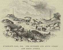
During the War of 1812 a series of fortifications and redoubts were put up nearby, including Blockhouse No. 1 (which still stands on a hill in the North Woods), as well Fort Clinton, Fort Fish and Nutter's Battery (along the north side of the Pass), remnants of which can still be seen.[10] There was also a gatehouse straddling the road just east of present-day Lasker Pool, near the grid coordinates of 107th Street and Sixth (Lenox) Avenue, where present-day East Drive makes its first downhill switchback. This 1860s route of East Drive was partially constructed over the old earthwork fortifications.
From 1847 till 1881 the most prominent structure on the site was the chapel of Mount St. Vincent's Academy (a convent school built around the old McGown house), which became the U.S. General Hospital or St. Joseph's Military Hospital, during the American Civil War from 1862 to 1865, after the Mount St. Vincent Academy moved north to its present campus in Riverdale.
From 1859 to 1863, Frederick Law Olmsted and his family lived in the Mount St. Vincent's buildings, while Olmsted directed the landscaping of Central Park.[11]
Post-Civil War
From the 1860s till the 1880s, the Park Commission leased out the old school grounds as a sculpture museum and tavern, while the hill continued to be known as Mount St. Vincent's. This created confusion for visiting parents who told their cab driver to take them to Mount St. Vincent's, and found themselves at a large, convivial saloon in Central Park, instead of a sedate convent school. Accordingly the Park Commission officially designated the region "McGown's Pass" [sic] on maps and signage, and renamed the "Mount St. Vincent's Hotel" roadhouse as "McGown's Pass Tavern."[12]
In 1906 a plaque commemorating the "McGown" family and the Pass was installed nearby at the Fort Clinton memorial.[13]
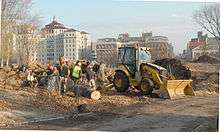
The last restaurant at the pass, McGown's Pass Tavern, was closed and razed 1915-1917. However its driveways and foundations remain and provide easy access for the Central Park Conservancy, which uses it as a composting area and has reverted to calling it "The Mount."[14]
References
- ↑ Christopher Colles, "From New York (1) to Stratford." Published 1792. Reproduced in Phelps Stokes, The Iconography of Manhattan Island, map viewable online here.
- ↑ Map of Upper Manhattan, Valentine's Manual, dated 1860, viewable here.
- ↑ Journal of the American-Irish Historical Society, Michael O'Brien," Historical Note, pp. 284-286.
- ↑ Clarence Cook, A Description of the Central Park in New York. 1869.
- 1 2 James Riker, Revised History of Harlem, 1906.
- ↑ New York Mercury, March 8, 1756. The advertisement is quoted in I. N. Phelps Stokes The Iconography of Manhattan Island, Volumes 3 and 6, 1928.
- ↑ The Journal of Lieutenant von Krafft, 1776-1784, p. 15 gives detailed descriptions of deployment and logistics of the time.
- ↑ Edward T. Williams, Niagara County, New York: A Concise Record of Her Progress and People, 1921. Leggett genealogy quoted online, accessed May 8, 2011
- ↑ Public Papers of George Clinton, quoted in Edward Hagaman Hall, p. 40.
- ↑ Central Park website.
- ↑ Melvin Kalfus, Frederick Law Olmsted: The Passion of a Public Artist. 1991.
- ↑ Edward Hagaman Hall, McGown's Pass and Vicinity (NY: 1905), 26, available online, accessed May 8, 2011
- ↑ New York Times: "Tablet is Unveiled at Old Fort Clinton, November 25, 1906, accessed May 8, 2011
- ↑ Central Park Conservancy site; confuses the various taverns in the region.