Mariana Plate
| Mariana Plate | |
|---|---|
 | |
| Type | Minor |
| Approx. Area | 360,000 km2[1] |
| Movement1 | north-west |
| Speed1 | 39-51mm/year |
| Features | Mariana Islands, Mariana Trench |
| 1Relative to the African Plate | |

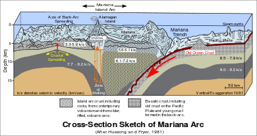
Cross section across the Mariana Plate
The Mariana Plate is a small tectonic plate located west of the Mariana Trench and forms the basement of the Mariana Islands. It is separated from the Philippine Sea Plate by a long divergent boundary with numerous transform fault offsets. The boundary between the Mariana and the Pacific Plate to the east is a subduction zone with the Pacific Plate subducting beneath the Mariana. The Mariana Trench forms the southeastern boundary and the Izu-Ogasawara Trench the northeastern boundary.[2]
The Mariana Islands earthquake of October 31, 2007 was a deep earthquake. It had a magnitude of 7.4 and occurred at 21.980° N. Lat. and 142.685° E. Long. at a depth of 261 km.[3]
References
- ↑ http://geology.about.com/library/bl/blplate_size_table.htm
- ↑ Bird, P. (2003). "An updated digital model of plate boundaries". Geochemistry, Geophysics, Geosystems. 4 (3): 1027. doi:10.1029/2001GC000252.
- ↑ "M7.2 Northern Mariana Islands Earthquake of 31 October 2007" (PDF). USGS. Retrieved 2009-01-08.
This article is issued from Wikipedia - version of the 5/4/2015. The text is available under the Creative Commons Attribution/Share Alike but additional terms may apply for the media files.
