Malsch (bei Wiesloch)
| Malsch | ||
|---|---|---|
|
Town hall | ||
| ||
 Malsch | ||
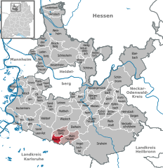
Location of Malsch within Rhein-Neckar-Kreis district 
 | ||
| Coordinates: 49°14′47″N 08°40′59″E / 49.24639°N 8.68306°ECoordinates: 49°14′47″N 08°40′59″E / 49.24639°N 8.68306°E | ||
| Country | Germany | |
| State | Baden-Württemberg | |
| Admin. region | Karlsruhe | |
| District | Rhein-Neckar-Kreis | |
| Government | ||
| • Mayor | Sibylle Würfel | |
| Area | ||
| • Total | 6.77 km2 (2.61 sq mi) | |
| Population (2015-12-31)[1] | ||
| • Total | 3,443 | |
| • Density | 510/km2 (1,300/sq mi) | |
| Time zone | CET/CEST (UTC+1/+2) | |
| Postal codes | 69254 | |
| Dialling codes | 07253 | |
| Vehicle registration | HD | |
| Website | www.malsch-weinort.de | |
Malsch is a town in the district of Rhein-Neckar in Baden-Württemberg in Germany.
Geography
Geographical Location
Malsch is located in the northwestern corner of the Kraichgau south of the cities of Wiesloch and Walldorf at the border of the Oberrheinischen Tiefebene. The town is located at the foot of the Letzenberg, a hill of 244 m height.
Neighboring towns
Adjacent towns are, starting from the north clockwise: Malschenberg, Rauenberg, Mühlhausen, Rettigheim, Östringen, Bad Schönborn, Kronau und St. Leon-Rot.
Weblinks
| Wikimedia Commons has media related to Malsch. |
- Gemeinde Malsch
- Bilder rund um Malsch und Letzenberg
- Natur- und Landschaftsschutzgebiet Hochholz-Kapellenbruch
References
This article is issued from Wikipedia - version of the 12/19/2015. The text is available under the Creative Commons Attribution/Share Alike but additional terms may apply for the media files.

