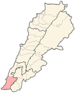
Mahrouna
| Mahrouna محرونة، | |
|---|---|
| Town | |
|
Mahrouna Municipality Building | |
 Mahrouna | |
| Coordinates: LB 33°13′8.25″N 35°20′33.92″E / 33.2189583°N 35.3427556°ECoordinates: LB 33°13′8.25″N 35°20′33.92″E / 33.2189583°N 35.3427556°E | |
| Grid position | 182/291 PAL |
| Country | Lebanon |
| Governorate | South Governorate |
| District | Tyre |
| Time zone | +2 |
| • Summer (DST) | +3 (UTC) |
Mahrouna (in Arabic: محرونة، محرونا) is a small agribusiness town located in the south of Lebanon.
It is situated at a distance of 100 kilometres from Beirut the co capital, and 18 kilometres to the southeast of the city of Tyre. Mahrouna stands at a height of 400 meter above sea level. The population is approximately 3800 inhabitant. This increases to 5000 in vacations and summer times, according to a municipal member.
Name
E. H. Palmer wrote that the name Mahrûneh came from "carded (as cotton)".[1]
History
In 1875 Victor Guérin found it to be a Metawileh village,[2] he further noted: "Here are traces of a surrounding wall, ancient materials, a tomb cut in the rock, and a quarry, a part of which has been formed into a tank."[3]
In 1881, the Palestine Exploration Fund's Survey of Western Palestine (SWP) described it as: "A village, built of stone, containing about 150 Metawileh; no houses of note ; situated on a hill, surrounded by olives, figs, and arable land, with a spring and cisterns."[4]
This peaceful quiet town is rich with its green surrounding. But it is especially famous for its oak trees hill which forms a natural park for the town’s residents. This hill has an ancient ruin at the top. Large squared stones arranged on top of each other which forms part of a solid wall corner.
The residents believe it is the remains of a small castle or stronghold.
Unfortunately, this greenly oak hill was bombarded several times, since the 1970s, by the Israeli jets. As a result, large numbers of the oak trees were burnt at some parts of the hill, especially in 2006.
The town is predominately inhabited by Muslims, though the surrounding area also has a significant Christian minority. Inhabitants are mostly close or distant relatives. Its known families by surnames are: Wehbi, Ne'meh, Awada, Makki, Shawraba, Salman, Abdullah and Kasem.
Mahrouna became a municipality in 2004. In this municipal elections, 9 municipal council members were elected for six years. Now The municipality runs the services required for the town independently. Although, it remains under the control of the central government.
One of the national and international artists born in Mahrouna is Haifa Wehbe, was Miss South Lebanon 1992 and Miss Lebanon 1996.
Gallery
.jpg) Old Town House
Old Town House Mahrouna Mosque
 Town's Green View
 Oak Tree Hill
References
Bibliography
- Conder, Claude Reignier; Kitchener, H. H. (1881). The Survey of Western Palestine: Memoirs of the Topography, Orography, Hydrography, and Archaeology. 1. London: Committee of the Palestine Exploration Fund.
- Guérin, Victor (1880). Description Géographique Historique et Archéologique de la Palestine (in French). 3: Galilee, pt. 2. Paris: L'Imprimerie Nationale.
- Palmer, E. H. (1881). The Survey of Western Palestine: Arabic and English Name Lists Collected During the Survey by Lieutenants Conder and Kitchener, R. E. Transliterated and Explained by E.H. Palmer. Committee of the Palestine Exploration Fund.
Sources
- Mr. H. Makki, British Journalist (The Author)
- Municipality of Mahrouna
- Ministry of Interior and Municipalities,Republic of Lebanon,
- View Map & technical info
External links
- Survey of Western Palestine, Map 2: IAA, Wikimedia commons
- Mahrouna, Localiban

