M8 Bridge to Nowhere
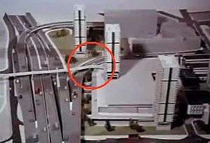
Bridge to Nowhere is a nickname used to refer to various unfinished structures around the M8 motorway in the centre of Glasgow, Scotland. They were built in the 1960s as part of the Glasgow Inner Ring Road project but left incomplete for several years. One 'bridge', at Charing Cross, was completed in the 1990s as an office block. The Anderston Footbridge, a pedestrian bridge south of St Patrick's church, was finally completed in 2013 as part of a walking and cycling route.[1]
A third 'Bridge to Nowhere' was created in 2008 following the demolition of a hotel a few blocks away from the M8.
Charing Cross Podium

The structure officially called the Charing Cross Podium, was always intended to have a development of some sort on the top level. However, the incomplete structure looked like a bridge and was often referred to as the 'Bridge to Nowhere'.
When the western flank of the inner ring road was being prepared for tender in the mid-1960s the designer, Scott Wilson & Partners, advised Glasgow Corporation to include the development as part of the motorway construction contract. This advice was ignored with the Corporation hoping that a developer would take on the project, along with the costs. The original plans were for an office complex – which would eventually evolve into what is now Elmbank Gardens – to make use of the structure.[2] In the end, the Elmbank scheme was scaled back and the result was the podium remained incomplete for over two decades, attracting much notoriety at a time when the entire M8 construction project was the subject of very divided public opinion. In the mid-1990s Glasgow District Council at last found an interested party, and a short time later an office block was built. Occupiers of the building known as Tay House include Barclays Bank.
Anderston Footbridge

The Anderston Footbridge, 600 m (660 yd) south of the Charing Cross Podium, was originally planned as the main pedestrian connection between the new housing estates on the western side of the motorway to the Anderston Cross Commercial Centre but the size of the latter development was scaled back in size – meaning that the bridge terminated in mid-air above the vacant land, which was eventually built upon in 1981 when a Holiday Inn hotel (nowadays the Glasgow Marriott) was constructed on the site.

As a highly visible structure, it assumed the title of 'Bridge to Nowhere' from the Charing Cross Podium after that was built on and lost its bridge-like appearance.
A proposal by charity Sustrans, under their national Connect2 programme, aimed to finish the construction, as well as connecting the bridge with a second one over the Clydeside Expressway. This should increase pedestrian and cycle access to central Glasgow on a route between Kelvingrove Park and the city centre. Sustrans won the funding in September 2011 – work to finally complete the bridge began in 2012 and was completed by July 2013.[3][4]
The third bridge
Glasgow gained a third "Bridge to Nowhere" in 2008 on a street a few hundred yards to the east of the Anderston Footbridge. The former Albany Hotel was demolished leaving the pedestrian bridge, connecting to the adjacent Anderston Centre, terminating in mid air over Bishop Lane at the end of Waterloo Street. The hotel was controversially razed[5] in preparation for a new complex called Bothwell Plaza. The hotel development received planning permission in 2009[6] but remains unbuilt (allegedly due to poor economic conditions).
References
- ↑ "Glasgow's 'Bridge to Nowhere' finally completed". BBC News. 7 July 2013.
- ↑ Williamson, Riches, Higgs (1990). Glasgow. Yale University Press. p. 214. ISBN 9780300096743.
- ↑ http://www.theglaswegian.co.uk/glasgow-news/news/2011/09/01/exclusive-m8-bridge-to-nowhere-to-be-finished-102692-23388033/
- ↑ "Glasgow's 'Bridge to Nowhere' finally completed". BBC News. BBC. 8 July 2013. Retrieved 8 July 2013.
- ↑ http://www.eveningtimes.co.uk/the-end-for-the-albany-as-150-face-axe-at-city-hotel-1.941705
- ↑ http://www.urbanrealm.com/news/1223/Bothwell_Plaza_rises_again.html
External links
- Sustrans Glasgow 'Connect 2' project: National Lottery funded project to complete the bridge as part of a walking and cycling route
- Glasgow City Council pages about the Sustrans Connect2 project
- The Herald Newspaper: Lottery bid to link up ‘bridge to nowhere’
- BBC News – success of the bid for funding to complete the bridge
- Images & map of the bridge to nowhere
- Hidden Glasgow – Bridge to Nowhere and Connect2 project photos
- Sauchiehall Street bridge: 55°51′58.29″N 4°16′16.87″W / 55.8661917°N 4.2713528°W
- Anderston footbridge: 55°51′38.53″N 4°16′12.29″W / 55.8607028°N 4.2700806°W