Lung Tsun Stone Bridge
.jpg)
The Lung Tsun Stone Bridge (Chinese: 龍津橋) is a former bridge in Hong Kong, buried during the construction of Kai Tak Airport, which connected the Kowloon Walled City to a pier.[1]
History

In middle of the nineteenth century, European merchants used Chinese junks to smuggle goods and opium to the mainland. The Viceroy of Liangguang ordered a checkpoint be set up in the water channel between Hong Kong and Macau. Due to the replenishment need for the customs ships, the stone bridge was proposed to be built and named after a nearby river: Lung Tsun.
Gambling was allowed in Hong Kong between 1867 and 1871, but was prohibited in 1872. The casinos moved to Kowloon Walled City. As a nearby pier, the Lung Tsun Stone Bridge become a hotspot for the foreign gamblers.[2]
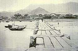
Construction on the bridge began in 1873 and was completed in 1875.[1] The bridge was about 210 metres (690 ft) long,[3] 2.6 metres (8.5 ft) wide, and built of granite. At the time, it was the longest and toughest stone pier in Hong Kong. It was divided into south and north.[4] Due to mud deposition, the length of the pier was extended to 300 metres (980 ft) with wood. During the Japanese occupation of Hong Kong, the bridge was covered up when the Kai Tak Airport was expanded.
Conservation
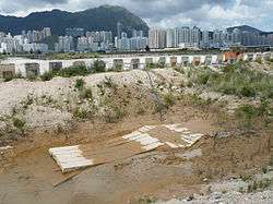
The bridge's remnants were first identified in April 2008.[5] Remnants of the bridge will be preserved in-situ as part of the redevelopment plan for the Kai Tak site.[1]
References
- 1 2 3 The Standard, Relic will serve as bridge to Kai Tak's past, May 18, 2010
- ↑ 舊機場發現龍津石橋遺蹟《蘋果日報》2008年6月21日,香港
- ↑ Civil Engineering and Development Department, Kowloon Development Office, "Agreement No. CE 35/2006(CE). Kai Tak Development Engineering Study. Further archaeological excavation report", August 2009
- ↑ 吴偉鴻,九龍龍津橋考古發現
- ↑ Antiquities and Monuments Office, "Remnants of Lung Tsun Stone Bridge in Kai Tak Area", Board Paper AAB/30/2009-10, December 2009
External links
- Antiquities and Monuments Office, "Discovery of Longjin Bridge in Kai Tak Area", Board Paper AAB/60/2007-08, June 2008
- "Major archaeological features identified at the Site by 2008-09 archaeological investigations with levels of significance"
- "Conservation Management Plan for the Site of Lung Tsun Stone Bridge", November 2009
| Wikimedia Commons has media related to Lung Tsun Stone Bridge. |
Coordinates: 22°19′44″N 114°11′41″E / 22.32889°N 114.19472°E