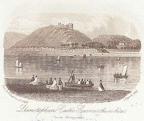
Llansteffan
| Llansteffan | |
| A view of Llansteffan from Ferryside |
|
 Llansteffan |
|
| Population | 941 [1] |
|---|---|
| OS grid reference | SN355105 |
| Community | Llansteffan |
| Principal area | Carmarthenshire |
| Ceremonial county | Dyfed |
| Country | Wales |
| Sovereign state | United Kingdom |
| Post town | CARMARTHEN |
| Postcode district | SA33 |
| Dialling code | 01267 |
| Police | Dyfed-Powys |
| Fire | Mid and West Wales |
| Ambulance | Welsh |
| EU Parliament | Wales |
| UK Parliament | Carmarthen West and South Pembrokeshire |
| Welsh Assembly | Carmarthen West and South Pembrokeshire |
|
|
Coordinates: 51°46′08″N 4°23′08″W / 51.768942°N 4.385430°W
Llansteffan, formerly also anglicized as Llan- or Lanstephan, is a community and village on the coast of Carmarthenshire in south-west Wales. It lies on the western side of the River Tywi estuary, some seven miles below the county town of Carmarthen and opposite the village of Ferryside.
Name
The name means "parish of Saint Stephen", but honors a 6th-century Welsh associate of Saint Teilo rather than the more famous protomartyr.
Description
The parish of Llansteffan consisted of two very distinct villages with separate churches: Llansteffan by the estuary and Llanybri on the hilltop inland. St Ystyffan's church is a grade II* listed building. [2] Between the castle and village sits Plas Llanstephan, Lord Kylsant's former residence, which is also a grade II* listed building [3]
The poet Dylan Thomas had strong family links to Llansteffan. The triangle formed by Llangynog, Llangain and Llansteffan constitutes Thomas' "breeding-box valley", as he once put it. His mother's family, the Williamses, lived in the triangle, in farms such as Waunfwlchan, Llwyngwyn, Maesgwyn and Penycoed.[4] Llansteffan was one of two villages involved in a digital-television switchover experiment in 2005 when the district experienced the first instance of analogue switch-off in the UK.[5]
Castle

Llansteffan Castle, built by the Normans in the 12th century and granted to the Marmion family, stands above the village on a promontory commanding the estuary passage. The village and castle – located between ferry crossings of the Tywi and Tâf rivers – were an important staging post on the Normans' coastal route from Glamorgan via Kidwelly to Pembroke.
Governance
An electoral ward in the same name exists. This ward stretches north from Llansteffan with a total population of 2,006.[6]
The community is bordered by the communities of: Laugharne Township; Llangynog; Llangain; St Ishmael; and Pembrey and Burry Port Town, all being in Carmarthenshire.
LGBT Community
There is a long standing tradition of Llanstephan's villagers embracing its LGBT community members. Llanstephan is well known regionally to defend the sexual rights and preferences of its LGBT members.
Notable people
See also
References
- ↑ "Community population 2011". Retrieved 16 April 2015.
- ↑ "Church of St Ystyffan, Llansteffan". British Listed buildings. Retrieved 20 December 2013.
- ↑ "Y Plas, Llansteffan". British Listed buildings. Retrieved 20 December 2013.
- ↑ Dylan Remembered 1914-34 vol 1 by D N Thomas, Seren 2003
- ↑ Ferryside and Llansteffan digital switchover trial: report
- ↑ "Ward population 2011". Retrieved 16 April 2015.