List of power stations in Wisconsin
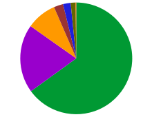
Wisconsin's electric power net generation by primary energy source, 2006.
[1] Coal 65%
Nuclear 19.8%
Natural gas 8.7%
Hydroelectric 2.7%
Other Renewable 2.2%
Petroleum 1.4%
Other 0.2%
This is a list of electricity-generating power stations in Wisconsin, sorted by type and name.
Nuclear power stations
Coal-fired
| Plant |
Location |
Coords. |
Notes |
| Alma Generating Station | Alma, Wisconsin | 44°18′30″N 91°54′39″W / 44.30833°N 91.91083°W / 44.30833; -91.91083 | |
| Columbia Energy Center | Portage, Wisconsin | 43°29′10″N 89°25′13″W / 43.48611°N 89.42028°W / 43.48611; -89.42028 | |
| Edgewater Generating Station | Sheboygan, Wisconsin | 43°42′56″N 87°42′23″W / 43.71556°N 87.70639°W / 43.71556; -87.70639 | |
| E. J. Stoneman Generating Station (Briefly operated burning Bio-Mass Fuel) | Cassville, Wisconsin | 42°42′30″N 90°59′5″W / 42.70833°N 90.98472°W / 42.70833; -90.98472 | Closed 2015.[2] |
| Genoa Generating Station | Genoa, Wisconsin | 43°33′33″N 91°13′55″W / 43.55917°N 91.23194°W / 43.55917; -91.23194 | |
| John P. Madgett Generating Station | Alma, Wisconsin | 44°18′11″N 91°54′45″W / 44.30306°N 91.91250°W / 44.30306; -91.91250 | |
| Nelson Dewey Generating Station | Cassville, Wisconsin | 42°43′21″N 91°0′31″W / 42.72250°N 91.00861°W / 42.72250; -91.00861 | . Closed 2015.[2] |
| Pleasant Prairie Power Plant (P4) | Pleasant Prairie, Wisconsin | 42°32′17″N 87°54′17″W / 42.53806°N 87.90472°W / 42.53806; -87.90472 | |
| J. P. Pulliam Generating Station | Green Bay, Wisconsin | 44°32′24″N 88°00′31″W / 44.54000°N 88.00861°W / 44.54000; -88.00861 | |
| Oak Creek Power Plant | Oak Creek, Wisconsin | 42°50′40″N 87°49′43″W / 42.84444°N 87.82861°W / 42.84444; -87.82861 | |
| Weston Generating Station | Rothschild, Wisconsin | 44°51′31″N 89°38′59″W / 44.85861°N 89.64972°W / 44.85861; -89.64972 | |
Gas-fired (or combined gas/coal)
| Plant |
Location |
Coords. |
Notes |
| Blackhawk Generating Station | Beloit, Wisconsin | 42°30′23″N 89°1′56″W / 42.50639°N 89.03222°W / 42.50639; -89.03222 | |
| Blount Generating Station | Madison, Wisconsin | 43°4′45″N 89°22′27″W / 43.07917°N 89.37417°W / 43.07917; -89.37417 | |
| Concord Generating Station | Watertown, Wisconsin | 43°10′5″N 88°41′13″W / 43.16806°N 88.68694°W / 43.16806; -88.68694 | |
| Fox Energy Center | Town of Kaukauna, Wisconsin | | |
| Germantown Power Plant | Germantown, Wisconsin | 43°11′46″N 88°9′1″W / 43.19611°N 88.15028°W / 43.19611; -88.15028 | |
| Paris Generating Station | Town of Paris, near Union Grove, Wisconsin | 42°39′57″N 88°00′47″W / 42.66583°N 88.01306°W / 42.66583; -88.01306 | |
| Port Washington Generating Station | Port Washington, Wisconsin | 43°58′37″N 87°52′12″W / 43.97694°N 87.87000°W / 43.97694; -87.87000 | |
| Riverside Energy Center | Town of Beloit, Wisconsin | 42°34′58″N 89°2′7″W / 42.58278°N 89.03528°W / 42.58278; -89.03528 | |
| RockGen Energy Center | Town of Christiana, Wisconsin | 42°58′37″N 89°2′55″W / 42.97694°N 89.04861°W / 42.97694; -89.04861 | |
| Rock River Generating Station | Town of Beloit, Wisconsin | 42°34′55″N 89°1′39″W / 42.58194°N 89.02750°W / 42.58194; -89.02750 | |
| Valley Power Plant | Milwaukee, Wisconsin | 43°1′47″N 87°55′26″W / 43.02972°N 87.92389°W / 43.02972; -87.92389 | |
| West Campus Cogeneration Facility | Madison, Wisconsin | | |
| Wheaton Generating Plant | Town of Wheaton, Wisconsin | 44°53′9″N 91°30′57″W / 44.88583°N 91.51583°W / 44.88583; -91.51583 | |
| Whitewater Cogen | Whitewater, Wisconsin | 42°51′19″N 88°43′48″W / 42.85528°N 88.73000°W / 42.85528; -88.73000 | |
Wind farms
Petroleum-fired
Hydro-electric
Hydro-electric power stations
- WE Energies operates 13 hydro facilities, totaling 89 MW.
References
External links