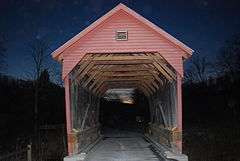
Laurel Creek Covered Bridge
|
Laurel Creek Covered Bridge | |
|
Laurel Creek Covered Bridge, February 2009 | |
  | |
| Location | County Route 23/4 west of County Route 219/11, Lillydale, West Virginia |
|---|---|
| Coordinates | 37°33′40″N 80°37′36″W / 37.56111°N 80.62667°WCoordinates: 37°33′40″N 80°37′36″W / 37.56111°N 80.62667°W |
| Area | less than one acre |
| Built | 1910 |
| MPS | West Virginia Covered Bridges TR |
| NRHP Reference # | 81000605[1] |
| Added to NRHP | June 4, 1981 |
Laurel Creek Covered Bridge is a historic covered bridge located near Lillydale, Monroe County, West Virginia. It was built in 1910. The shortest covered bridge in the state,[2] it measures 34 feet, 6 inches long and 13 feet, 2 1/2 inches wide. It has wood siding painted red and a galvanized metal roof. By 1981, it was one of only 17 covered bridges left in West Virginia.[3]
It was listed on the National Register of Historic Places in 1981.[1]
References
- 1 2 National Park Service (2010-07-09). "National Register Information System". National Register of Historic Places. National Park Service.
- ↑ Adkins, Leonard M. (May 2, 2011). Explorer's Guide West Virginia (Second Edition). The Countryman Press. p. 27. Retrieved 7 July 2013.
- ↑ E.L. Kemp (n.d.). "National Register of Historic Places Inventory Nomination Form: Laurel Creek Covered Bridge" (PDF). State of West Virginia, West Virginia Division of Culture and History, Historic Preservation. Retrieved 2011-08-18.
This article is issued from Wikipedia - version of the 11/28/2016. The text is available under the Creative Commons Attribution/Share Alike but additional terms may apply for the media files.

