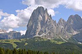
Langkofel
| Langkofel | |
|---|---|
| Saslonch / Sassolungo | |
 | |
| Highest point | |
| Elevation | 3,181 m (10,436 ft) |
| Prominence | 1,124 m (3,688 ft) [1] |
| Coordinates | 46°31′29″N 11°44′7″E / 46.52472°N 11.73528°ECoordinates: 46°31′29″N 11°44′7″E / 46.52472°N 11.73528°E |
| Geography | |
 Langkofel Location in the Alps | |
| Location | South Tyrol, Italy |
| Parent range | Dolomites |
| Climbing | |
| First ascent | 1869 |
The Saslonch, Sassolungo or Langkofel (Ladin: Saslonch; Italian: Sassolungo [ˌsassoˈluŋɡo]; German: Langkofel [laŋˈkofl]) (3,181m) is the highest mountain of the Langkofel Group in the Dolomites in South Tyrol, Italy. The name translates to "long peak" / "long rock" in all three languages. It stands over the Ladin community of Val Gardena.
Climbing
The mountain is a serious climb, and it is essential to bring full climbing equipment. Pitons line the main routes. The normal route starts at the Sella Pass, at about 2,200m above sea level. Paul Grohmann was the first to reach the summit in 1869.[2]
References
- ↑ "Langkofel - peakbagger". peakbagger.com. Retrieved 12 February 2015.
- ↑ "Sassolungo - Langkofel - summitpost". Summitpost. Retrieved 12 February 2015.
- Alpenverein South Tyrol (German)
External links
![]() Media related to Langkofel group at Wikimedia Commons
Media related to Langkofel group at Wikimedia Commons
This article is issued from Wikipedia - version of the 9/1/2016. The text is available under the Creative Commons Attribution/Share Alike but additional terms may apply for the media files.