Karaburma
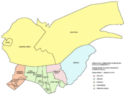
Karaburma (Serbian Cyrillic: Карабурма) is an urban neighborhood of Belgrade, the capital of Serbia. It is located in Belgrade's municipality of Palilula.
Location
Karaburma is located between the neighborhoods of Zvezdara (south), Bogoslovija (west), Ada Huja (north), Rospi Ćuprija (east) and Ćalije (southeast). Its entire southern border (Dragoslava Srejovića street) is also municipal border between Palilula and Zvezdara, for the most part dividing it from the Zvezdara woods. Northern border is the Višnjička street while the eastern is the Mirijevo Boulevard.

History

Karaburma was geographically a headland peaking into the Danube. When the neighboring island of Ada Huja was connected to the mainland thus becoming a peninsula, Karaburma's area on the right bank of Danube also became known as Ada Huja, so Karaburma is now few hundred meters away from the river.
The oldest settlement known by name on the territory of modern Belgrade was found in the Karaburma area. Remains of the Celtic (and later Roman) settlement of Singidunum were found near Karaburma and neighboring Rospi Ćuprija, including necropolis (Horseman's grave 16[1]) rich in artefacts and parts of dunum, fortress, so it is believed that the settlement itself was located here.[2]
For centuries area was a true swamp with vast quick clay areas so it was avoided by humans ever since the Roman period. Today non-existing thermal springs along the Danube's bank fumed and heated the water so the swamp was in constant mist. In 19th century Serbian prince Miloš Obrenović ordered that Karaburma will be the official place of death sentences executions (until 1912) which just added to the notoriety of the area.
Until Belgrade's expansion after the World War I, Karaburma was sparsely inhabited with small and scattered shanty towns. Today it is a modern neighborhood 10 minutes away from downtown Belgrade with good transportation connections.
The name, Karaburma, is Turkish for black ring which is supposed to mean that the area was forbidden, that is, it should be avoided by people. However, this may be an example of folk etymology as the old Ottoman and Austrian maps name the area Kajaburun (Kaya-burun) which is Turkish for rocky headland.
On September 1, 1955, Karaburma became one of the municipalities of Belgrade, but already on January 3, 1957 it was incorporated into the municipality of Palilula. Today, it roughly consists of Stara Karaburma (Old Karaburma), the western section, and Karaburma-Dunav or Nova Karaburma (Karaburma-Danube or New Karaburma), the eastern section. The south-eastern corner, which extends into Ćalije, is also known as Karaburma II.
Characteristics
Karaburma is a residential area, and one of the most populous neighborhoods of Belgrade, with a combined population of 34,343 (several local communities which make the neighborhood). Some of distinctive features are two green markets, the VII Belgrade Gymnasium and the stadium of OFK Beograd.
References
- ↑ http://arheologie.ulbsibiu.ro/publicatii/bibliotheca/acta%20V%20special%20number/915dacian.htm
- ↑ "Antički period "Antiquity period"". Grad Beograd (in Serbian). 2008-07-03. Retrieved 2008-07-28. External link in
|work=(help)
- Beograd - plan grada; M@gic M@p, 2006; ISBN 86-83501-53-1
- Beograd - plan i vodič; Geokarta, 1999; ISBN 86-459-0006-8
Coordinates: 44°49′N 20°30′E / 44.817°N 20.500°E
| Wikimedia Commons has media related to Karaburma. |