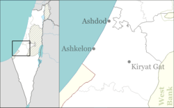
Kannot
| Kannot כַּנּוֹת | |
|---|---|
 | |
 Kannot | |
| Coordinates: 31°48′8.27″N 34°45′8.64″E / 31.8022972°N 34.7524000°ECoordinates: 31°48′8.27″N 34°45′8.64″E / 31.8022972°N 34.7524000°E | |
| District | Southern |
| Council | Be'er Tuvia |
| Founded | 1952 |
| Founded by | Histadrut Workers' Council |
| Population (2015)[1] | 355 |
| Name meaning | Seedlings |
| Website | kannot.org.il |
Kannot (Hebrew: כַּנּוֹת, eng. Seedlings) is an educational institution and youth village in central Israel. Located near Gedera, it falls under the jurisdiction of Be'er Tuvia Regional Council. In 2015 it had a population of 355.
Etymology
It is named after an occasional word, just mentioned once: in the Bible in Psalm 80:16:[2] (God, watch over) "the seedling your right hand has planted".
History
The village was founded in 1952 by the Workers' Council of the Histadrut and belongs to the Na'amat organisation.
References
- ↑ "List of localities, in Alphabetical order" (PDF). Israel Central Bureau of Statistics. Retrieved 16 October 2016.
- ↑ Place Names in Israel. A Compendium of Place Names in Israel compiled from various sources. Translated from Hebrew, Jerusalem 1962 (Israel Prime Minister’s Office. The Israeli Program for Scientific Translations) p.211 (Location of the book: Ben Zvi Institute Library, 12 Abarbanel St., Jerusalem; in the online-catalogue: )
Bitan, Hanna: 1948-1998: Fifty Years of 'Hityashvut': Atlas of Names of Settlements in Israel, Jerusalem 1999, Carta, p.31, ISBN 965-220-423-4 (Hebrew)
External links
- Official website (Hebrew)
This article is issued from Wikipedia - version of the 9/6/2016. The text is available under the Creative Commons Attribution/Share Alike but additional terms may apply for the media files.