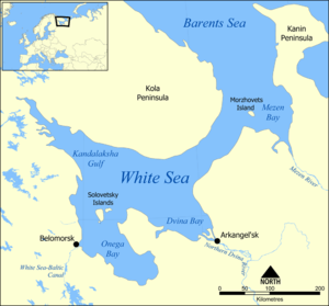
Kandalaksha Gulf
| Kandalaksha Gulf | |
|---|---|
 Kandalaksha Gulf | |
|
Kandalaksha Gulf: Northwest gulf of the White Sea | |
| Coordinates | 66°55′N 32°45′E / 66.917°N 32.750°E |
| Type | Gulf |
| Basin countries | Russia |
| Max. depth | 300 m (980 ft) |
The Kandalaksha Gulf (Russian: Кандалакшский залив, Skolt Sami: Käddluhtt), Finnish: Kantalahti) is located in the Republic of Karelia, and Murmansk Oblast in northwestern Russia. Forming the north-western corner of the White Sea, it is one of four large bays and gulfs of this sea, the others being the Onega Bay (south-west), the Dvina Bay (south), and the Mezen Bay (south east).[1]
The Kola Peninsula lies north of the Kandalaksha Gulf. The city of Kandalaksha is located at the northern tip of the gulf; the new oil port Vitino, some 10 km to the south. There are hundreds of skerries in the gulf. The gulf is shallow, reaching 300 meters on its western side. In 1976, the upper reaches of the Gulf were designated a RAMSAR wetland of international importance, notably as a breeding ground for migratory waterfowl such as the sea duck.[2]
Kandalaksha Nature Reserve (Кандалакшский заповедник) includes parts of the coastline and many of the islands in the Gulf. It is one of Russia's oldest nature reserves, established in 1932.[3]

Coordinates: 66°55′N 32°45′E / 66.917°N 32.750°E
See also
References
- ↑ "Kandalaksha State Nature Reserve". Kandalaksha State Nature Reserve (Official Site) (in Russian). Ministry of Natural Resources and Ecology of the Russian Federation. Retrieved 29 May 2016.
- ↑ "Kandalaksha Bay". RAMSAR Site Directory. RAMSAR International. Retrieved 29 May 2016.
- ↑ "Kandalaksha Zapovednik". State Nature Reserves of Russia (in Russian). Ministry of Natural Resources and Ecology of the Russian Federation. Retrieved 29 May 2016.
External links
- Kandalaksha Nature Reserve (English Summary), and some practical travel information on the City of Kandalaksha, also in English.
- Topographic map of Kandalaksha Gulf (Finnish and Russian)
