Kamnik pod Krimom
| Kamnik pod Krimom | |
|---|---|
 | |
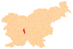
 Kamnik pod Krimom Location in Slovenia | |
| Coordinates: 45°57′24.85″N 14°24′28.25″E / 45.9569028°N 14.4078472°ECoordinates: 45°57′24.85″N 14°24′28.25″E / 45.9569028°N 14.4078472°E | |
| Country |
|
| Traditional region | Inner Carniola |
| Statistical region | Central Slovenia |
| Municipality | Brezovica |
| Area | |
| • Total | 8.37 km2 (3.23 sq mi) |
| Elevation | 339.1 m (1,112.5 ft) |
| Population (2002) | |
| • Total | 750 |
| [1] | |
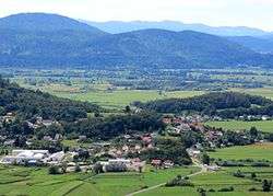
Kamnik pod Krimom (pronounced [ˈkaːmnik pɔt ˈkɾiːmɔm]) is a village in the Municipality of Brezovica in central Slovenia. It lies on the edge of the marshlands south of the capital Ljubljana. The municipality is part of the traditional region of Inner Carniola and is now included in the Central Slovenia Statistical Region.[2]
Name
Kamnik was attested in 1143 as Stein (and as Stain in 1147 and Steine in 1205). The Slovene name was originally *Kam(en)ьnikъ, derived from the adjective form of the noun *kamy (accusative *kamenь) 'stone', referring to rocky terrain.[3] The name of the settlement was changed from Kamnik to Kamnik pod Krimom (literally, 'Kamnik below Mount Krim') in 1953.[4]
Church
The local church, built in the centre of the village, is dedicated to Saint Florian and belongs to the Parish of Preserje. It was first mentioned in written documents dating to 1526, but was restyled in the 18th century.[5]
References
- ↑ Statistical Office of the Republic of Slovenia
- ↑ Brezovica municipal site
- ↑ Snoj, Marko. 2009. Etimološki slovar slovenskih zemljepisnih imen. Ljubljana: Modrijan and Založba ZRC, p. 183.
- ↑ Spremembe naselij 1948–95. 1996. Database. Ljubljana: Geografski inštitut ZRC SAZU, DZS.
- ↑ Slovenian Ministry of Culture register of national heritage reference number ešd 2180
External links
 Media related to Kamnik pod Krimom at Wikimedia Commons
- Kamnik pod Krimom on Geopedia
