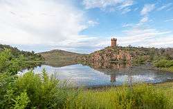
Lake Jed Johnson
| Lake Jed Johnson | |
|---|---|
 | |
| Location | Wichita Mountains, Comanche County, Oklahoma, US |
| Coordinates | 34°43′45″N 98°36′0″W / 34.72917°N 98.60000°WCoordinates: 34°43′45″N 98°36′0″W / 34.72917°N 98.60000°W |
| Type | reservoir |
| Primary inflows | Blue Beaver Creek |
| Primary outflows | Blue Beaver Creek |
| Catchment area | 5.35 sq mi (13.9 km2) |
| Basin countries | United States |
| Managing agency | U.S. Fish and Wildlife Service |
| Built | 1940 |
| Surface area | 57.5 acres (23.3 ha) |
| Water volume | 1,190 acre·ft (0.00147 km3) |
| Surface elevation | 1,608 feet (490 m) |
| Settlements | Cache, Medicine Park, Meers |
| References | [1][2] |
Lake Jed Johnson, named for Jed Johnson (1888–1963), is third largest of thirteen small reservoirs in the Wichita Mountains National Wildlife Refuge, located in southwestern Oklahoma. It has a surface area of 57.5 acres (233,000 m2) and can be accessed by a boat ramp. The area is home to deer, elk, Longhorn cattle and bison, and there are many opportunities for boating, fishing, hunting, and hiking throughout the refuge.
See also
References
- ↑ Varghese, Saji (1998). "Hydrologic Investigation of Red River Basin" (pdf). Oklahoma Water Resources Board. OK.gov - Oklahoma State Portal. pp. 76, 78. Retrieved 2012-10-03.
- ↑ "Blue Beaver Creek near Cache, Oklahoma (Station 07311200)". Hydrologic Benchmark Network ~ U.S. Geological Survey. U.S. Department of the Interior.
External links
- "Blue Beaver Creek". Geographic Names Information System. United States Geological Survey. Retrieved 2012-10-03.
- "Lake Jed Johnson". Geographic Names Information System. United States Geological Survey. Retrieved 2009-05-04.
- Wichita Mountains National Wildlife Refuge
This article is issued from Wikipedia - version of the 9/12/2015. The text is available under the Creative Commons Attribution/Share Alike but additional terms may apply for the media files.