Jabal Sawda
Not to be confused with Jabal Sawda'.
| Jabal Sawda | |
|---|---|
 | |
| Highest point | |
| Elevation | Around 3,000 metres (9,843 ft). |
| Coordinates | 18°16′02″N 42°22′05″E / 18.26722°N 42.36806°ECoordinates: 18°16′02″N 42°22′05″E / 18.26722°N 42.36806°E |
| Geography | |
 Jabal Sawda | |
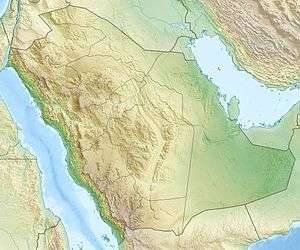
Jabal Sawda is a peak located in Saudi Arabia, with an elevation of around 3,000 metres (9,843 ft).
Most authorities claim that the peak, with a questioned elevation of 3,133 m, is the highest point in Saudi Arabia, but SRTM data indicates an elevation of 2,985 m, with higher elevations elsewhere in the country.
Climate
| Climate data for Sawda (2946 m) | |||||||||||||
|---|---|---|---|---|---|---|---|---|---|---|---|---|---|
| Month | Jan | Feb | Mar | Apr | May | Jun | Jul | Aug | Sep | Oct | Nov | Dec | Year |
| Average high °C (°F) | 14.8 (58.6) |
16.1 (61) |
18.0 (64.4) |
20.2 (68.4) |
22.8 (73) |
25.9 (78.6) |
24.8 (76.6) |
24.5 (76.1) |
24.0 (75.2) |
20.0 (68) |
17.0 (62.6) |
15.2 (59.4) |
20.3 (68.5) |
| Daily mean °C (°F) | 8.2 (46.8) |
9.4 (48.9) |
11.5 (52.7) |
13.3 (55.9) |
15.7 (60.3) |
18.2 (64.8) |
18.3 (64.9) |
18.2 (64.8) |
16.3 (61.3) |
12.6 (54.7) |
9.8 (49.6) |
8.2 (46.8) |
13.3 (55.9) |
| Average low °C (°F) | 1.7 (35.1) |
2.7 (36.9) |
5.1 (41.2) |
6.5 (43.7) |
8.6 (47.5) |
10.5 (50.9) |
11.8 (53.2) |
12.0 (53.6) |
8.6 (47.5) |
5.2 (41.4) |
2.7 (36.9) |
1.2 (34.2) |
6.4 (43.5) |
| Average precipitation mm (inches) | 18 (0.71) |
40 (1.57) |
63 (2.48) |
70 (2.76) |
28 (1.1) |
7 (0.28) |
29 (1.14) |
46 (1.81) |
8 (0.31) |
4 (0.16) |
10 (0.39) |
9 (0.35) |
332 (13.07) |
| Source: Climate-data.org | |||||||||||||
See also
External links
- (English) "Jabal Sawdā', Saudi Arabia". Peakbagger.com.
This article is issued from Wikipedia - version of the 10/27/2016. The text is available under the Creative Commons Attribution/Share Alike but additional terms may apply for the media files.