Isla Gonzalo
|
The island with its weather station | |
 Isla Gonzalo or Isla Bote Isla Gonzalo is the second largest of the Diego Ramírez Islands | |
| Geography | |
|---|---|
| Coordinates | 56°31′30″S 68°41′00″W / 56.52500°S 68.68333°W |
| Archipelago | Diego Ramírez Islands |
| Area | 0.38 km2 (0.15 sq mi) |
| Administration | |
| Region | Magallanes |
| Province | Antártica |
| Commune | Cabo de Hornos |
| Additional information | |
| NGA UFI=-883269 | |
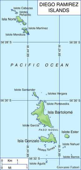
Isla Gonzalo is a subantarctic island, uninhabited except for a weather and research station operated by the Chilean Navy. With an area of 38 ha it is the second largest (the largest being Isla Bartolomé) of the Chilean Diego Ramírez Archipelago, lying in the Drake Passage between the continents of South America and Antarctica. It is an important breeding site for black-browed (over 6000 pairs) and grey-headed (over 4000 pairs) albatrosses, as well as for southern giant petrels.[1][2]

The island is an important breeding site for grey-headed albatrosses
See also
- List of islands of Chile
- List of Antarctic and sub-Antarctic islands
- List of fjords, channels, sounds and straits of Chile
References
- ↑ "Island – Isla Bartolome". Island Group - Islas Diego Ramirez. Agreement on the Conservation of Albatrosses and Petrels. 2011. Retrieved 2011-07-21.
- ↑ Robertson, Graham; Moreno, Carlos A.; Lawton, Kieran; Arata, Javier; Valencia, Jose; Kirkwood, Roger. (2007). "An estimate of the population sizes of Black-browed (Thalassarche melanophrys) and Grey-headed (T. chrysostoma) Albatrosses breeding in the Diego Ramírez Archipelago, Chile". Emu. 107: 239–244. doi:10.1071/mu07028.
External links
- Islands of Chile @ United Nations Environment Programme
- World island information @ WorldIslandInfo.com
- South America Island High Points above 1000 meters
- United States Hydrographic Office, South America Pilot (1916)
Coordinates: 56°31′30″S 68°41′00″W / 56.52500°S 68.68333°W
This article is issued from Wikipedia - version of the 11/16/2016. The text is available under the Creative Commons Attribution/Share Alike but additional terms may apply for the media files.

