Hongan-ji Nagoya Betsuin
.jpg)
The Hongan-ji Betsuin (本願寺派名古屋別院) is a Jōdo Shinshū buddhist temple located in Naka ward, Nagoya in central Japan.
The temple is a short distance south of Ōsu Kannon Station.
History


.jpg)
The temple is run by the Ikko sect of Jōdo Shinshū. The temple is also called Nishi Honganji (西別院) as opposed to the Higashi Honganji (東本願寺名古屋別院). It dates back to about 1500 CE when chief abbot Rennyo's 13th child, Renjun, built Gansyo-ji in the Japanese cedar groves of Ise province. Later it fell on hard times and was renovated. In the early Edo period it was moved to the current location at the time of the construction of Nagoya Castle.
It was patronized by Baishō-in, one of the Shogun's main concubines.
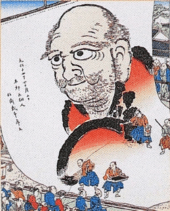
On October 5, 1817 Hokusai painted at the temple the "Big Daruma" on paper, measuring 18x10.8 metres, impressing many onlookers. Although the original was destroyed in 1945, promotional handbills from that time survived and are preserved at the Nagoya City Museum.
In 1874, close to the temple, a medical training centre, the predecessor of Nagoya University's School of Medicine, was set up for medical research, practice and education. Later the centre was moved to Tennozaki on the banks of the Hori River.
The wooden building and artwork were largely destroyed during the bombing of Nagoya in World War II in May 1945. It was rebuilt in a pseudo-ancient Indian style. Only the wooden shōrō survived the war and remains intact.
Features
On the grounds is a bronze statue to the founder Shinran.
The Hongan-ji Betsuin houses the ashes of deceased persons, which are kept in their urns in metal lockers on the ground floor of the temple. By request from relatives, monks will perform prayer services for a fee.
See also
- Tsukiji Hongan-ji in Tokyo, which has architectural resemblance
External links
![]() Media related to Honganji Nagoya Betsuin at Wikimedia Commons
Media related to Honganji Nagoya Betsuin at Wikimedia Commons
Coordinates: 35°09′26″N 136°53′58″E / 35.15722°N 136.89944°E