Hohenwart
For the nearby abbey, see Hohenwart Abbey.
| Hohenwart | ||
|---|---|---|
| ||
 Hohenwart | ||
Location of Hohenwart within Pfaffenhofen a.d.Ilm district 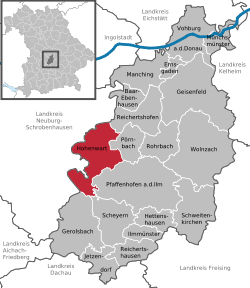 | ||
| Coordinates: 48°36′N 11°23′E / 48.600°N 11.383°ECoordinates: 48°36′N 11°23′E / 48.600°N 11.383°E | ||
| Country | Germany | |
| State | Bavaria | |
| Admin. region | Oberbayern | |
| District | Pfaffenhofen a.d.Ilm | |
| Government | ||
| • Mayor | Manfred Russer (CSU) | |
| Area | ||
| • Total | 52.21 km2 (20.16 sq mi) | |
| Population (2015-12-31)[1] | ||
| • Total | 4,569 | |
| • Density | 88/km2 (230/sq mi) | |
| Time zone | CET/CEST (UTC+1/+2) | |
| Postal codes | 86558 | |
| Dialling codes | 08443 | |
| Vehicle registration | PAF | |
| Website | www.markt-hohenwart.de | |

Hohenwart is a municipality in the district of Pfaffenhofen in Bavaria in Germany.
References
- ↑ "Fortschreibung des Bevölkerungsstandes". Bayerisches Landesamt für Statistik und Datenverarbeitung (in German). June 2016.
Towns and municipalities in Pfaffenhofen | ||
|---|---|---|
This article is issued from Wikipedia - version of the 6/21/2015. The text is available under the Creative Commons Attribution/Share Alike but additional terms may apply for the media files.